Älmsta geodata
Älmsta (Stockholm) is a populated place; located in Sweden in Europe/Stockholm (GMT+2) time zone. With population of 1,376 people, there are 692 cities with bigger population in this country. Compared to other cities in Sweden, 73.4% of cities are located further ↓South; 92.4% of cities are located further ←West and 56% of cities have higher elevation than Älmsta. Note1


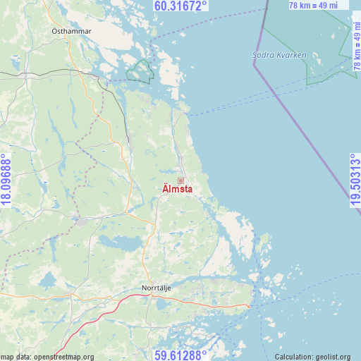
Älmsta GPS coordinates[2]
59° 58' 0.012" North, 18° 48' 0" East
| Map corner | latitude | longitude |
|---|---|---|
| Upper-left | 60.31672°, | 18.09688° |
| Center: | 59.96667°, | 18.8° |
| Lower-right: | 59.61288°, | 19.50313° |
| Map W x H: | 78.3×78.3 km | = 48.7×48.7mi |
| max Lat: | 67.85572° ⇑26.6% North |
| Älmsta: | 59.96667° |
| min Lat: | ⇓73.4% South 55.34337° |
| min Long | Älmsta | max Long |
| 11.1712° | 18.8° | 24.13676° |
| W 92.4%⇐ | ⇒7.6% E |
Elevation
Elevation of Älmsta is 41 m = 135 ft, and this is 41.6 m = 136 ft below average elevation for this country.
| Max E: |
663 m = 2175 ft | 56% |
| Avg. | 82.6 m = 271 ft | |
| Älmsta | 41 m = 135 ft | |
Min E: |
-1 m = -3 ft | 44% |
See also: Sweden elevation on elevation.city.
Geographical zone
Älmsta is located in North temperate zone (between Tropic of Cancer and the Arctic Circle). Distance of this North polar circle is 733.5 km =455.8 mi to North.| Distance of | km | miles | from Älmsta |
|---|---|---|---|
| North Pole | 3339.4 | 2075 | to North |
| Arctic Circle | 733.5 | 455.8 | to North |
| Tropic Cancer | 4061.7 | 2523.8 | to South |
| Equator | 6667.7 | 4143.1 | to South |


Nearby cities:
15 places around Älmsta: (largest is in red/bold)
• Anneberg
37.2 km =23.1 mi,  325°
325°
• Arnö
19.1 km =11.9 mi, 330°
• Bergshamra
38.1 km =23.7 mi,  194°
194°
• Edsbro
19 km =11.8 mi,  244°
244°
• Gräddö
25.8 km =16 mi,  149°
149°
• Hallstavik
14.5 km =9 mi,  309°
309°
• Knutby
30.5 km =19 mi,  257°
257°
• Marieberg
34 km =21.1 mi, 330°
• Norrtälje
23.8 km =14.8 mi, 192°
• Nykvarn
33.5 km =20.8 mi, 236°
• Rimbo
34.1 km =21.2 mi,  225°
225°
• Rörvik
9.3 km =5.8 mi,  143°
143°
• Skänninge
18 km =11.2 mi, 258°
• Strömma
30.8 km =19.1 mi,  158°
158°
• Svanberga
15.5 km =9.6 mi,  208°
208°
Sources, notices
• [Note1] Compared only with cities in Sweden existing in our database
• [Src1] Map data: © OpenStreetMap contributors (CC-BY-SA)
• [Src2] Other city data from geonames.org with taken over terms of usage.
• [Src3] Geographical zone / Annual Mean Temperature by Robert A. Rohde @ Wikipedia
