Nybro geodata
Nybro (Kalmar) is a seat of a second-order administrative division; located in Sweden in Europe/Stockholm (GMT+2) time zone. With population of 13,039 people, there are 120 cities with bigger population in this country. Compared to other cities in Sweden, 80.6% of cities are located further ↑North; 61% of cities are located further ←West and 65.7% of cities have lower elevation than Nybro. Note1


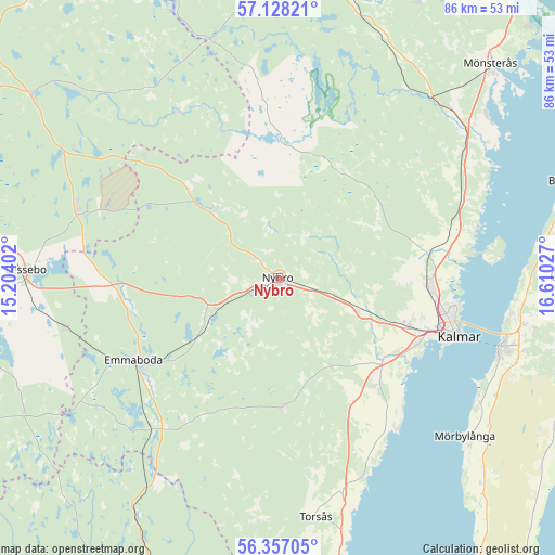
Nybro GPS coordinates[2]
56° 44' 40.596" North, 15° 54' 25.704" East
| Map corner | latitude | longitude |
|---|---|---|
| Upper-left | 57.12821°, | 15.20402° |
| Center: | 56.74461°, | 15.90714° |
| Lower-right: | 56.35705°, | 16.61027° |
| Map W x H: | 85.7×85.7 km | = 53.3×53.3mi |
| max Lat: | 67.85572° ⇑80.6% North |
| Nybro: | 56.74461° |
| min Lat: | ⇓19.4% South 55.34337° |
| min Long | Nybro | max Long |
| 11.1712° | 15.90714° | 24.13676° |
| W 61%⇐ | ⇒39% E |
Elevation
Elevation of Nybro is 85 m = 279 ft, and this is 2.4 m = 8 ft above average elevation for this country.
| Max E: |
663 m = 2175 ft | 34.3% |
| Nybro | 85 m 279 ft | |
| Avg. | 82.6 m = 271 ft | |
Min E: |
-1 m = -3 ft | 65.7% |
See also: Sweden elevation on elevation.city.
Geographical zone
Nybro is located in North temperate zone (between Tropic of Cancer and the Arctic Circle). Distance of this North polar circle is 1091.8 km =678.4 mi to North.| Distance of | km | miles | from Nybro |
|---|---|---|---|
| North Pole | 3697.7 | 2297.6 | to North |
| Arctic Circle | 1091.8 | 678.4 | to North |
| Tropic Cancer | 3703.5 | 2301.2 | to South |
| Equator | 6309.4 | 3920.5 | to South |


Nearby cities:
15 places around Nybro: (largest is in red/bold)
• Alstermo
29.7 km =18.5 mi,  328°
328°
• Emmaboda
25.8 km =16 mi,  241°
241°
• Hagby
27.4 km =17 mi,  141°
141°
• Kalmar
29.2 km =18.1 mi,  108°
108°
• Kosta
33 km =20.5 mi,  289°
289°
• Lindsdal
24 km =14.9 mi,  92°
92°
• Ljungbyholm
20.1 km =12.5 mi,  127°
127°
• Orrefors
14.5 km =9 mi,  317°
317°
• Påryd
19.8 km =12.3 mi,  178°
178°
• Rinkabyholm
24.4 km =15.2 mi,  115°
115°
• Rockneby
27.7 km =17.2 mi,  76°
76°
• Smedby
22 km =13.7 mi, 110°
• Trekanten
13.7 km =8.5 mi, 111°
• Vassmolösa
22.6 km =14 mi, 135°
• Vissefjärda
30.7 km =19.1 mi,  220°
220°
Sources, notices
• [Note1] Compared only with cities in Sweden existing in our database
• [Src1] Map data: © OpenStreetMap contributors (CC-BY-SA)
• [Src2] Other city data from geonames.org with taken over terms of usage.
• [Src3] Geographical zone / Annual Mean Temperature by Robert A. Rohde @ Wikipedia
