Orrefors geodata
Orrefors (Kalmar) is a populated place; located in Sweden in Europe/Stockholm (GMT+2) time zone. With population of 766 people, there are 1000 cities with bigger population in this country. Compared to other cities in Sweden, 79.5% of cities are located further ↑North; 58.7% of cities are located further ←West and 84.5% of cities have lower elevation than Orrefors. Note1


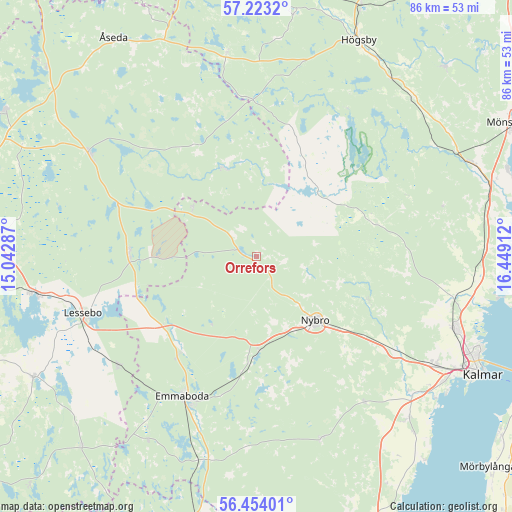
Orrefors GPS coordinates[2]
56° 50' 26.088" North, 15° 44' 45.564" East
| Map corner | latitude | longitude |
|---|---|---|
| Upper-left | 57.2232°, | 15.04287° |
| Center: | 56.84058°, | 15.74599° |
| Lower-right: | 56.45401°, | 16.44912° |
| Map W x H: | 85.5×85.5 km | = 53.1×53.1mi |
| max Lat: | 67.85572° ⇑79.5% North |
| Orrefors: | 56.84058° |
| min Lat: | ⇓20.5% South 55.34337° |
| min Long | Orrefors | max Long |
| 11.1712° | 15.74599° | 24.13676° |
| W 58.7%⇐ | ⇒41.3% E |
Elevation
Elevation of Orrefors is 166 m = 545 ft, and this is 83.4 m = 274 ft above average elevation for this country.
| Max E: |
663 m = 2175 ft | 15.5% |
| Orrefors | 166 m 545 ft | |
| Avg. | 82.6 m = 271 ft | |
Min E: |
-1 m = -3 ft | 84.5% |
See also: Sweden elevation on elevation.city.
Geographical zone
Orrefors is located in North temperate zone (between Tropic of Cancer and the Arctic Circle). Distance of this North polar circle is 1081.1 km =671.8 mi to North.| Distance of | km | miles | from Orrefors |
|---|---|---|---|
| North Pole | 3687 | 2291 | to North |
| Arctic Circle | 1081.1 | 671.8 | to North |
| Tropic Cancer | 3714.2 | 2307.9 | to South |
| Equator | 6320.1 | 3927.1 | to South |


Nearby cities:
15 places around Orrefors: (largest is in red/bold)
• Alstermo
15.7 km =9.8 mi,  339°
339°
• Emmaboda
26.4 km =16.4 mi,  208°
208°
• Kosta
21.3 km =13.2 mi,  270°
270°
• Lenhovda
33.2 km =20.6 mi,  302°
302°
• Lessebo
30.6 km =19 mi,  251°
251°
• Lindsdal
35.8 km =22.2 mi,  109°
109°
• Ljungbyholm
34.5 km =21.4 mi,  131°
131°
• Nybro
14.5 km =9 mi,  137°
137°
• Påryd
32.2 km =20 mi,  161°
161°
• Rockneby
37 km =23 mi,  96°
96°
• Skruv
29.5 km =18.3 mi,  231°
231°
• Smedby
35.5 km =22.1 mi,  121°
121°
• Trekanten
27.5 km =17.1 mi, 124°
• Vassmolösa
37.1 km =23.1 mi, 136°
• Vissefjärda
35.6 km =22.1 mi,  196°
196°
Sources, notices
• [Note1] Compared only with cities in Sweden existing in our database
• [Src1] Map data: © OpenStreetMap contributors (CC-BY-SA)
• [Src2] Other city data from geonames.org with taken over terms of usage.
• [Src3] Geographical zone / Annual Mean Temperature by Robert A. Rohde @ Wikipedia
