Emmaboda geodata
Emmaboda (Kalmar) is a seat of a second-order administrative division; located in Sweden in Europe/Stockholm (GMT+2) time zone. With population of 4,818 people, there are 283 cities with bigger population in this country. Compared to other cities in Sweden, 82.4% of cities are located further ↑North; 56% of cities are located further ←West and 76.9% of cities have lower elevation than Emmaboda. Note1


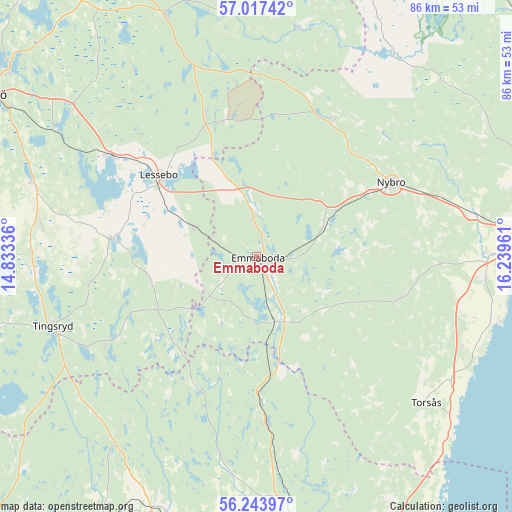
Emmaboda GPS coordinates[2]
56° 37' 57.648" North, 15° 32' 11.328" East
| Map corner | latitude | longitude |
|---|---|---|
| Upper-left | 57.01742°, | 14.83336° |
| Center: | 56.63268°, | 15.53648° |
| Lower-right: | 56.24397°, | 16.23961° |
| Map W x H: | 86×86 km | = 53.4×53.4mi |
| max Lat: | 67.85572° ⇑82.4% North |
| Emmaboda: | 56.63268° |
| min Lat: | ⇓17.6% South 55.34337° |
| min Long | Emmaboda | max Long |
| 11.1712° | 15.53648° | 24.13676° |
| W 56%⇐ | ⇒44% E |
Elevation
Elevation of Emmaboda is 127 m = 417 ft, and this is 44.4 m = 146 ft above average elevation for this country.
| Max E: |
663 m = 2175 ft | 23.1% |
| Emmaboda | 127 m 417 ft | |
| Avg. | 82.6 m = 271 ft | |
Min E: |
-1 m = -3 ft | 76.9% |
See also: Sweden elevation on elevation.city.
Geographical zone
Emmaboda is located in North temperate zone (between Tropic of Cancer and the Arctic Circle). Distance of this North polar circle is 1104.2 km =686.1 mi to North.| Distance of | km | miles | from Emmaboda |
|---|---|---|---|
| North Pole | 3710.1 | 2305.3 | to North |
| Arctic Circle | 1104.2 | 686.1 | to North |
| Tropic Cancer | 3691 | 2293.5 | to South |
| Equator | 6297 | 3912.8 | to South |


Nearby cities:
15 places around Emmaboda: (largest is in red/bold)
• Alstermo
38.5 km =23.9 mi,  10°
10°
• Hovmantorp
29.6 km =18.4 mi,  305°
305°
• Kosta
24.9 km =15.5 mi,  339°
339°
• Lessebo
21 km =13 mi, 309°
• Nybro
25.8 km =16 mi,  61°
61°
• Orrefors
26.4 km =16.4 mi,  28°
28°
• Påryd
24.4 km =15.2 mi,  107°
107°
• Skruv
11.5 km =7.1 mi,  295°
295°
• Söderåkra
38.3 km =23.8 mi,  122°
122°
• Tingsryd
36.2 km =22.5 mi,  250°
250°
• Torsås
37.4 km =23.2 mi,  130°
130°
• Trekanten
36.2 km =22.5 mi,  78°
78°
• Tving
36.6 km =22.7 mi,  186°
186°
• Vissefjärda
11.4 km =7.1 mi,  165°
165°
• Väckelsång
37.9 km =23.5 mi,  270°
270°
Sources, notices
• [Note1] Compared only with cities in Sweden existing in our database
• [Src1] Map data: © OpenStreetMap contributors (CC-BY-SA)
• [Src2] Other city data from geonames.org with taken over terms of usage.
• [Src3] Geographical zone / Annual Mean Temperature by Robert A. Rohde @ Wikipedia
