Malung geodata
Malung (Dalarna) is a seat of a second-order administrative division; located in Sweden in Europe/Stockholm (GMT+2) time zone. With population of 4,927 people, there are 277 cities with bigger population in this country. Compared to other cities in Sweden, 80.4% of cities are located further ↓South; 67.5% of cities are located further →East and 96.1% of cities have lower elevation than Malung. Note1


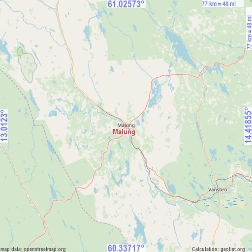
Malung GPS coordinates[2]
60° 40' 59.844" North, 13° 42' 55.512" East
| Map corner | latitude | longitude |
|---|---|---|
| Upper-left | 61.02573°, | 13.0123° |
| Center: | 60.68329°, | 13.71542° |
| Lower-right: | 60.33717°, | 14.41855° |
| Map W x H: | 76.6×76.6 km | = 47.6×47.6mi |
| max Lat: | 67.85572° ⇑19.6% North |
| Malung: | 60.68329° |
| min Lat: | ⇓80.4% South 55.34337° |
| min Long | Malung | max Long |
| 11.1712° | 13.71542° | 24.13676° |
| W 32.5%⇐ | ⇒67.5% E |
Elevation
Elevation of Malung is 300 m = 984 ft, and this is 217.4 m = 713 ft above average elevation for this country.
| Max E: |
663 m = 2175 ft | 3.9% |
| Malung | 300 m 984 ft | |
| Avg. | 82.6 m = 271 ft | |
Min E: |
-1 m = -3 ft | 96.1% |
See also: Sweden elevation on elevation.city.
Geographical zone
Malung is located in North temperate zone (between Tropic of Cancer and the Arctic Circle). Distance of this North polar circle is 653.8 km =406.3 mi to North.| Distance of | km | miles | from Malung |
|---|---|---|---|
| North Pole | 3259.7 | 2025.5 | to North |
| Arctic Circle | 653.8 | 406.3 | to North |
| Tropic Cancer | 4141.4 | 2573.3 | to South |
| Equator | 6747.3 | 4192.6 | to South |


Nearby cities:
15 places around Malung: (largest is in red/bold)
• Björbo
60.1 km =37.3 mi,  114°
114°
• Ekshärad
58 km =36 mi,  191°
191°
• Floda
62 km =38.5 mi, 108°
• Färnäs
60.9 km =37.8 mi,  54°
54°
• Järna
39.3 km =24.4 mi,  115°
115°
• Malungsfors
10.6 km =6.6 mi,  301°
301°
• Mora
57.5 km =35.7 mi, 51°
• Nusnäs
58.9 km =36.6 mi,  57°
57°
• Selja
55 km =34.2 mi, 47°
• Siljansnäs
62.7 km =39 mi,  79°
79°
• Sollerön
55.3 km =34.4 mi, 62°
• Sälen
57.3 km =35.6 mi,  334°
334°
• Vansbro
33.9 km =21.1 mi, 124°
• Älvdalen
63 km =39.1 mi,  16°
16°
• Östnor
57 km =35.4 mi, 46°
Sources, notices
• [Note1] Compared only with cities in Sweden existing in our database
• [Src1] Map data: © OpenStreetMap contributors (CC-BY-SA)
• [Src2] Other city data from geonames.org with taken over terms of usage.
• [Src3] Geographical zone / Annual Mean Temperature by Robert A. Rohde @ Wikipedia
