Ekshärad geodata
Ekshärad (Värmland) is a populated place; located in Sweden in Europe/Stockholm (GMT+2) time zone. With population of 1,020 people, there are 802 cities with bigger population in this country. Compared to other cities in Sweden, 75.6% of cities are located further ↓South; 71.3% of cities are located further →East and 81.3% of cities have lower elevation than Ekshärad. Note1


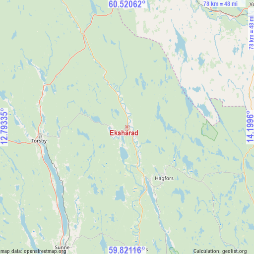
Ekshärad GPS coordinates[2]
60° 10' 21.9" North, 13° 29' 47.292" East
| Map corner | latitude | longitude |
|---|---|---|
| Upper-left | 60.52062°, | 12.79335° |
| Center: | 60.17275°, | 13.49647° |
| Lower-right: | 59.82116°, | 14.1996° |
| Map W x H: | 77.8×77.8 km | = 48.3×48.3mi |
| max Lat: | 67.85572° ⇑24.4% North |
| Ekshärad: | 60.17275° |
| min Lat: | ⇓75.6% South 55.34337° |
| min Long | Ekshärad | max Long |
| 11.1712° | 13.49647° | 24.13676° |
| W 28.7%⇐ | ⇒71.3% E |
Elevation
Elevation of Ekshärad is 150 m = 492 ft, and this is 67.4 m = 221 ft above average elevation for this country.
| Max E: |
663 m = 2175 ft | 18.7% |
| Ekshärad | 150 m 492 ft | |
| Avg. | 82.6 m = 271 ft | |
Min E: |
-1 m = -3 ft | 81.3% |
See also: Sweden elevation on elevation.city.
Geographical zone
Ekshärad is located in North temperate zone (between Tropic of Cancer and the Arctic Circle). Distance of this North polar circle is 710.6 km =441.5 mi to North.| Distance of | km | miles | from Ekshärad |
|---|---|---|---|
| North Pole | 3316.5 | 2060.8 | to North |
| Arctic Circle | 710.6 | 441.5 | to North |
| Tropic Cancer | 4084.7 | 2538.1 | to South |
| Equator | 6690.6 | 4157.3 | to South |


Nearby cities:
15 places around Ekshärad: (largest is in red/bold)
• Deje
63.4 km =39.4 mi,  181°
181°
• Edane
71.1 km =44.2 mi,  211°
211°
• Filipstad
63.4 km =39.4 mi,  143°
143°
• Fredriksberg
49.3 km =30.6 mi,  95°
95°
• Hagfors
19.2 km =11.9 mi,  149°
149°
• Järna
62.4 km =38.8 mi,  50°
50°
• Lesjöfors
43.9 km =27.3 mi,  119°
119°
• Malung
58 km =36 mi,  11°
11°
• Malungsfors
62.4 km =38.8 mi,  2°
2°
• Molkom
64.8 km =40.3 mi,  168°
168°
• Munkfors
37.3 km =23.2 mi, 175°
• Sunne
42.1 km =26.2 mi, 207°
• Torsby
27.3 km =17 mi,  261°
261°
• Uddeholm
18.6 km =11.6 mi,  158°
158°
• Vansbro
54.8 km =34.1 mi, 46°
Sources, notices
• [Note1] Compared only with cities in Sweden existing in our database
• [Src1] Map data: © OpenStreetMap contributors (CC-BY-SA)
• [Src2] Other city data from geonames.org with taken over terms of usage.
• [Src3] Geographical zone / Annual Mean Temperature by Robert A. Rohde @ Wikipedia
