Ljungby geodata
Ljungby (Kronoberg) is a seat of a second-order administrative division; located in Sweden in Europe/Stockholm (GMT+2) time zone. With population of 15,785 people, there are 102 cities with bigger population in this country. Compared to other cities in Sweden, 79.6% of cities are located further ↑North; 65.1% of cities are located further →East and 79.5% of cities have lower elevation than Ljungby. Note1


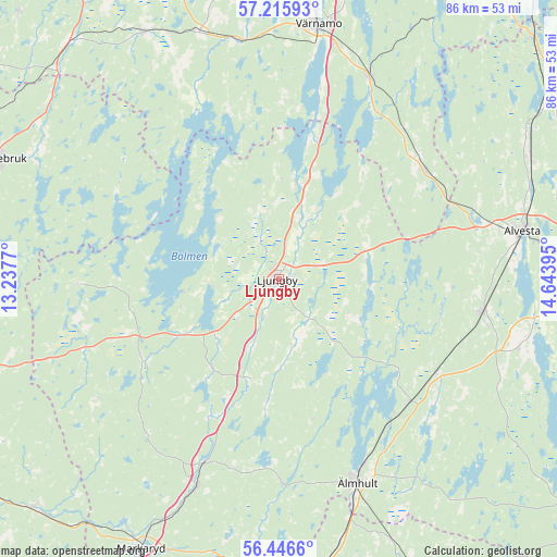
Ljungby GPS coordinates[2]
56° 49' 59.664" North, 13° 56' 26.952" East
| Map corner | latitude | longitude |
|---|---|---|
| Upper-left | 57.21593°, | 13.2377° |
| Center: | 56.83324°, | 13.94082° |
| Lower-right: | 56.4466°, | 14.64395° |
| Map W x H: | 85.5×85.5 km | = 53.1×53.1mi |
| max Lat: | 67.85572° ⇑79.6% North |
| Ljungby: | 56.83324° |
| min Lat: | ⇓20.4% South 55.34337° |
| min Long | Ljungby | max Long |
| 11.1712° | 13.94082° | 24.13676° |
| W 34.9%⇐ | ⇒65.1% E |
Elevation
Elevation of Ljungby is 142 m = 466 ft, and this is 59.4 m = 195 ft above average elevation for this country.
| Max E: |
663 m = 2175 ft | 20.5% |
| Ljungby | 142 m 466 ft | |
| Avg. | 82.6 m = 271 ft | |
Min E: |
-1 m = -3 ft | 79.5% |
See also: Sweden elevation on elevation.city.
Geographical zone
Ljungby is located in North temperate zone (between Tropic of Cancer and the Arctic Circle). Distance of this North polar circle is 1081.9 km =672.3 mi to North.| Distance of | km | miles | from Ljungby |
|---|---|---|---|
| North Pole | 3687.8 | 2291.5 | to North |
| Arctic Circle | 1081.9 | 672.3 | to North |
| Tropic Cancer | 3713.3 | 2307.3 | to South |
| Equator | 6319.3 | 3926.6 | to South |


Nearby cities:
15 places around Ljungby: (largest is in red/bold)
• Alvesta
38.1 km =23.7 mi,  78°
78°
• Bor
34.4 km =21.4 mi,  23°
23°
• Diö
27.9 km =17.3 mi,  142°
142°
• Forsheda
37.4 km =23.2 mi,  349°
349°
• Grimslöv
37.8 km =23.5 mi,  107°
107°
• Lagan
9.6 km =6 mi, 15°
• Liatorp
27.2 km =16.9 mi,  132°
132°
• Lidhult
30.9 km =19.2 mi,  270°
270°
• Rydaholm
27.9 km =17.3 mi,  53°
53°
• Ryssby
14.2 km =8.8 mi,  74°
74°
• Strömsnäsbruk
34.3 km =21.3 mi,  203°
203°
• Traryd
30.6 km =19 mi, 202°
• Unnaryd
28.8 km =17.9 mi,  296°
296°
• Vislanda
31.5 km =19.6 mi,  100°
100°
• Älmhult
33.6 km =20.9 mi,  158°
158°
Sources, notices
• [Note1] Compared only with cities in Sweden existing in our database
• [Src1] Map data: © OpenStreetMap contributors (CC-BY-SA)
• [Src2] Other city data from geonames.org with taken over terms of usage.
• [Src3] Geographical zone / Annual Mean Temperature by Robert A. Rohde @ Wikipedia
