Strömsnäsbruk geodata
Strömsnäsbruk (Kronoberg) is a populated place; located in Sweden in Europe/Stockholm (GMT+2) time zone. With population of 2,246 people, there are 486 cities with bigger population in this country. Compared to other cities in Sweden, 83.4% of cities are located further ↑North; 67.4% of cities are located further →East and 75.9% of cities have lower elevation than Strömsnäsbruk. Note1


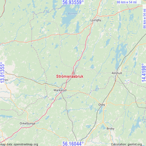
Strömsnäsbruk GPS coordinates[2]
56° 33' 0" North, 13° 43' 0.012" East
| Map corner | latitude | longitude |
|---|---|---|
| Upper-left | 56.93559°, | 13.01355° |
| Center: | 56.55°, | 13.71667° |
| Lower-right: | 56.16044°, | 14.4198° |
| Map W x H: | 86.2×86.2 km | = 53.6×53.6mi |
| max Lat: | 67.85572° ⇑83.4% North |
| Strömsnäsbruk: | 56.55° |
| min Lat: | ⇓16.6% South 55.34337° |
| min Long | Strömsnäsbruk | max Long |
| 11.1712° | 13.71667° | 24.13676° |
| W 32.6%⇐ | ⇒67.4% E |
Elevation
Elevation of Strömsnäsbruk is 124 m = 407 ft, and this is 41.4 m = 136 ft above average elevation for this country.
| Max E: |
663 m = 2175 ft | 24.1% |
| Strömsnäsbruk | 124 m 407 ft | |
| Avg. | 82.6 m = 271 ft | |
Min E: |
-1 m = -3 ft | 75.9% |
See also: Sweden elevation on elevation.city.
Geographical zone
Strömsnäsbruk is located in North temperate zone (between Tropic of Cancer and the Arctic Circle). Distance of this North polar circle is 1113.4 km =691.8 mi to North.| Distance of | km | miles | from Strömsnäsbruk |
|---|---|---|---|
| North Pole | 3719.3 | 2311.1 | to North |
| Arctic Circle | 1113.4 | 691.8 | to North |
| Tropic Cancer | 3681.9 | 2287.8 | to South |
| Equator | 6287.8 | 3907.1 | to South |


Nearby cities:
15 places around Strömsnäsbruk: (largest is in red/bold)
• Bjärnum
28.9 km =18 mi,  180°
180°
• Diö
32 km =19.9 mi,  73°
73°
• Hästveda
32.4 km =20.1 mi,  155°
155°
• Killeberg
24.7 km =15.3 mi,  109°
109°
• Knäred
24.3 km =15.1 mi,  261°
261°
• Kyrkhult
27.6 km =17.1 mi,  270°
270°
• Ljungby
34.3 km =21.3 mi,  23°
23°
• Markaryd
12.3 km =7.6 mi,  216°
216°
• Osby
25.3 km =15.7 mi,  137°
137°
• Sjörröd
32.1 km =19.9 mi, 157°
• Timsfors
11 km =6.8 mi,  227°
227°
• Traryd
3.8 km =2.4 mi,  32°
32°
• Vittsjö
23.2 km =14.4 mi,  188°
188°
• Älmhult
25.8 km =16 mi,  89°
89°
• Åsljunga
33.7 km =20.9 mi, 219°
Sources, notices
• [Note1] Compared only with cities in Sweden existing in our database
• [Src1] Map data: © OpenStreetMap contributors (CC-BY-SA)
• [Src2] Other city data from geonames.org with taken over terms of usage.
• [Src3] Geographical zone / Annual Mean Temperature by Robert A. Rohde @ Wikipedia
