Rörvik geodata
Rörvik (Jönköping) is a populated place; located in Sweden in Europe/Stockholm (GMT+2) time zone. With population of 582 people, there are 1195 cities with bigger population in this country. Compared to other cities in Sweden, 75.2% of cities are located further ↑North; 55.9% of cities are located further →East and 91.2% of cities have lower elevation than Rörvik. Note1


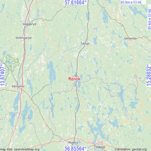
Rörvik GPS coordinates[2]
57° 14' 17.16" North, 14° 34' 37.884" East
| Map corner | latitude | longitude |
|---|---|---|
| Upper-left | 57.61664°, | 13.87407° |
| Center: | 57.2381°, | 14.57719° |
| Lower-right: | 56.85564°, | 15.28032° |
| Map W x H: | 84.6×84.6 km | = 52.6×52.6mi |
| max Lat: | 67.85572° ⇑75.2% North |
| Rörvik: | 57.2381° |
| min Lat: | ⇓24.8% South 55.34337° |
| min Long | Rörvik | max Long |
| 11.1712° | 14.57719° | 24.13676° |
| W 44.1%⇐ | ⇒55.9% E |
Elevation
Elevation of Rörvik is 215 m = 705 ft, and this is 132.4 m = 434 ft above average elevation for this country.
| Max E: |
663 m = 2175 ft | 8.8% |
| Rörvik | 215 m 705 ft | |
| Avg. | 82.6 m = 271 ft | |
Min E: |
-1 m = -3 ft | 91.2% |
See also: Sweden elevation on elevation.city.
Geographical zone
Rörvik is located in North temperate zone (between Tropic of Cancer and the Arctic Circle). Distance of this North polar circle is 1036.9 km =644.3 mi to North.| Distance of | km | miles | from Rörvik |
|---|---|---|---|
| North Pole | 3642.8 | 2263.5 | to North |
| Arctic Circle | 1036.9 | 644.3 | to North |
| Tropic Cancer | 3758.4 | 2335.4 | to South |
| Equator | 6364.3 | 3954.6 | to South |


Nearby cities:
15 places around Rörvik: (largest is in red/bold)
• Bodafors
30 km =18.6 mi,  14°
14°
• Bor
28.2 km =17.5 mi,  241°
241°
• Burseryd
18.9 km =11.7 mi,  40°
40°
• Korsberga
33.7 km =20.9 mi,  77°
77°
• Lammhult
8 km =5 mi,  177°
177°
• Landsbro
24.1 km =15 mi,  53°
53°
• Linneryd
31.3 km =19.4 mi,  305°
305°
• Moheda
26.5 km =16.5 mi, 181°
• Myresjö
28.4 km =17.6 mi, 54°
• Rottne
31.4 km =19.5 mi,  141°
141°
• Rydaholm
32.6 km =20.3 mi,  209°
209°
• Stockaryd
8.9 km =5.5 mi, 6°
• Sävsjö
19.1 km =11.9 mi,  15°
15°
• Vrigstad
14.1 km =8.8 mi,  331°
331°
• Värnamo
32.9 km =20.4 mi,  259°
259°
Sources, notices
• [Note1] Compared only with cities in Sweden existing in our database
• [Src1] Map data: © OpenStreetMap contributors (CC-BY-SA)
• [Src2] Other city data from geonames.org with taken over terms of usage.
• [Src3] Geographical zone / Annual Mean Temperature by Robert A. Rohde @ Wikipedia
