Rannebergen geodata
Rannebergen (Västra Götaland) is a populated place; located in Sweden in Europe/Stockholm (GMT+2) time zone. With population of 4,364 people, there are 309 cities with bigger population in this country. Compared to other cities in Sweden, 64.2% of cities are located further ↑North; 94% of cities are located further →East and 74.1% of cities have lower elevation than Rannebergen. Note1
Administrative division(s):
- Level 1: Västra Götaland
- Level 2: Göteborgs stad
- Level 3: Angered
- Level 4: Angered socken


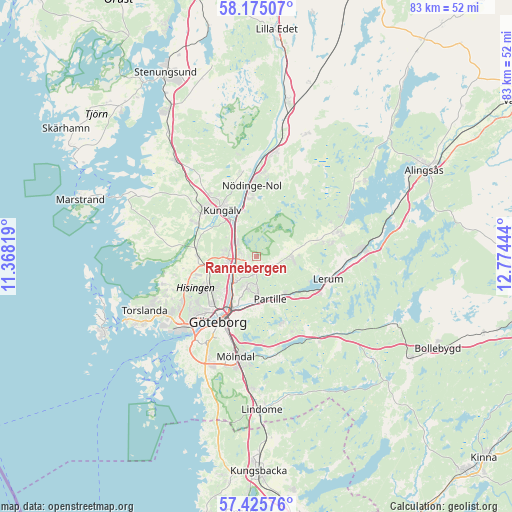
Rannebergen GPS coordinates[2]
57° 48' 8.496" North, 12° 4' 16.716" East
| Map corner | latitude | longitude |
|---|---|---|
| Upper-left | 58.17507°, | 11.36819° |
| Center: | 57.80236°, | 12.07131° |
| Lower-right: | 57.42576°, | 12.77444° |
| Map W x H: | 83.3×83.3 km | = 51.8×51.8mi |
| max Lat: | 67.85572° ⇑64.2% North |
| Rannebergen: | 57.80236° |
| min Lat: | ⇓35.8% South 55.34337° |
| min Long | Rannebergen | max Long |
| 11.1712° | 12.07131° | 24.13676° |
| W 6%⇐ | ⇒94% E |
Elevation
Elevation of Rannebergen is 115 m = 377 ft, and this is 32.4 m = 106 ft above average elevation for this country.
| Max E: |
663 m = 2175 ft | 25.9% |
| Rannebergen | 115 m 377 ft | |
| Avg. | 82.6 m = 271 ft | |
Min E: |
-1 m = -3 ft | 74.1% |
See also: Sweden elevation on elevation.city.
Geographical zone
Rannebergen is located in North temperate zone (between Tropic of Cancer and the Arctic Circle). Distance of this North polar circle is 974.2 km =605.3 mi to North.| Distance of | km | miles | from Rannebergen |
|---|---|---|---|
| North Pole | 3580 | 2224.5 | to North |
| Arctic Circle | 974.2 | 605.3 | to North |
| Tropic Cancer | 3821.1 | 2374.3 | to South |
| Equator | 6427 | 3993.6 | to South |


Nearby cities:
15 places around Rannebergen: (largest is in red/bold)
• Angered
2.4 km =1.5 mi,  137°
137°
• Eriksbo
3.9 km =2.4 mi,  206°
206°
• Furulund
10.2 km =6.3 mi,  158°
158°
• Gårdsten
2.5 km =1.6 mi,  276°
276°
• Hammarkullen
3.2 km =2 mi,  220°
220°
• Jonsered
8.7 km =5.4 mi, 136°
• Kungälv
9.3 km =5.8 mi,  324°
324°
• Kyrkobyn
9.2 km =5.7 mi,  268°
268°
• Kåhög
7.5 km =4.7 mi, 140°
• Lerum
12.2 km =7.6 mi,  106°
106°
• Lövgärdet
2.4 km =1.5 mi,  307°
307°
• Olofstorp
5.9 km =3.7 mi,  87°
87°
• Partille
7.3 km =4.5 mi, 163°
• Surte
4.2 km =2.6 mi, 307°
• Öjersjö
12.1 km =7.5 mi, 161°
Sources, notices
• [Note1] Compared only with cities in Sweden existing in our database
• [Src1] Map data: © OpenStreetMap contributors (CC-BY-SA)
• [Src2] Other city data from geonames.org with taken over terms of usage.
• [Src3] Geographical zone / Annual Mean Temperature by Robert A. Rohde @ Wikipedia
