Rolfstorp geodata
Rolfstorp (Halland) is a populated place; located in Sweden in Europe/Stockholm (GMT+2) time zone. With population of 537 people, there are 1257 cities with bigger population in this country. Compared to other cities in Sweden, 76.6% of cities are located further ↑North; 89% of cities are located further →East and 68% of cities have lower elevation than Rolfstorp. Note1


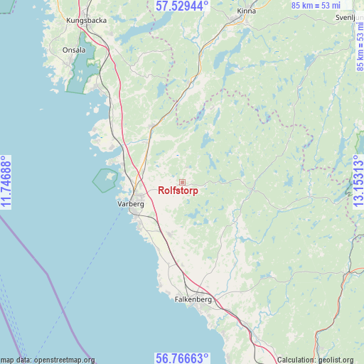
Rolfstorp GPS coordinates[2]
57° 9' 0" North, 12° 27' 0" East
| Map corner | latitude | longitude |
|---|---|---|
| Upper-left | 57.52944°, | 11.74688° |
| Center: | 57.15°, | 12.45° |
| Lower-right: | 56.76663°, | 13.15313° |
| Map W x H: | 84.8×84.8 km | = 52.7×52.7mi |
| max Lat: | 67.85572° ⇑76.6% North |
| Rolfstorp: | 57.15° |
| min Lat: | ⇓23.4% South 55.34337° |
| min Long | Rolfstorp | max Long |
| 11.1712° | 12.45° | 24.13676° |
| W 11%⇐ | ⇒89% E |
Elevation
Elevation of Rolfstorp is 93 m = 305 ft, and this is 10.4 m = 34 ft above average elevation for this country.
| Max E: |
663 m = 2175 ft | 32% |
| Rolfstorp | 93 m 305 ft | |
| Avg. | 82.6 m = 271 ft | |
Min E: |
-1 m = -3 ft | 68% |
See also: Sweden elevation on elevation.city.
Geographical zone
Rolfstorp is located in North temperate zone (between Tropic of Cancer and the Arctic Circle). Distance of this North polar circle is 1046.7 km =650.4 mi to North.| Distance of | km | miles | from Rolfstorp |
|---|---|---|---|
| North Pole | 3652.6 | 2269.6 | to North |
| Arctic Circle | 1046.7 | 650.4 | to North |
| Tropic Cancer | 3748.6 | 2329.3 | to South |
| Equator | 6354.5 | 3948.5 | to South |


Nearby cities:
15 places around Rolfstorp: (largest is in red/bold)
• Bua
22 km =13.7 mi,  296°
296°
• Horred
22.8 km =14.2 mi,  4°
4°
• Långås
18.5 km =11.5 mi,  180°
180°
• Skällinge
3.8 km =2.4 mi,  15°
15°
• Träslövsläge
14.8 km =9.2 mi,  224°
224°
• Trönninge
9.5 km =5.9 mi,  266°
266°
• Trönningenäs
13.6 km =8.5 mi,  264°
264°
• Tvååker
12.4 km =7.7 mi,  194°
194°
• Tångaberg
13.7 km =8.5 mi,  281°
281°
• Ullared
16.2 km =10.1 mi,  96°
96°
• Varberg
13 km =8.1 mi,  247°
247°
• Veddige
14.7 km =9.1 mi,  331°
331°
• Vessigebro
22.1 km =13.7 mi,  146°
146°
• Väröbacka
19.5 km =12.1 mi, 304°
• Årnäs
15.6 km =9.7 mi,  293°
293°
Sources, notices
• [Note1] Compared only with cities in Sweden existing in our database
• [Src1] Map data: © OpenStreetMap contributors (CC-BY-SA)
• [Src2] Other city data from geonames.org with taken over terms of usage.
• [Src3] Geographical zone / Annual Mean Temperature by Robert A. Rohde @ Wikipedia
