Kramfors geodata
Kramfors (Västernorrland) is a seat of a second-order administrative division; located in Sweden in Europe/Stockholm (GMT+2) time zone. With population of 6,582 people, there are 217 cities with bigger population in this country. Compared to other cities in Sweden, 88.7% of cities are located further ↓South; 82.6% of cities are located further ←West and 99.8% of cities have higher elevation than Kramfors. Note1
Administrative division(s):
- Level 1: Västernorrland
- Level 2: Kramfors Kommun
- Level 3: Gudmundrå
- Level 4: Kramfors socken


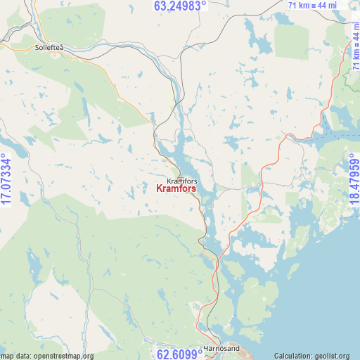
Kramfors GPS coordinates[2]
62° 55' 53.796" North, 17° 46' 35.256" East
| Map corner | latitude | longitude |
|---|---|---|
| Upper-left | 63.24983°, | 17.07334° |
| Center: | 62.93161°, | 17.77646° |
| Lower-right: | 62.6099°, | 18.47959° |
| Map W x H: | 71.2×71.2 km | = 44.2×44.2mi |
| max Lat: | 67.85572° ⇑11.3% North |
| Kramfors: | 62.93161° |
| min Lat: | ⇓88.7% South 55.34337° |
| min Long | Kramfors | max Long |
| 11.1712° | 17.77646° | 24.13676° |
| W 82.6%⇐ | ⇒17.4% E |
Elevation
Elevation of Kramfors is 1 m = 3 ft, and this is 81.6 m = 268 ft below average elevation for this country.
| Max E: |
663 m = 2175 ft | 99.8% |
| Avg. | 82.6 m = 271 ft | |
| Kramfors | 1 m = 3 ft | |
Min E: |
-1 m = -3 ft | 0.2% |
See also: Sweden elevation on elevation.city.
Geographical zone
Kramfors is located in North temperate zone (between Tropic of Cancer and the Arctic Circle). Distance of this North polar circle is 403.8 km =250.9 mi to North.| Distance of | km | miles | from Kramfors |
|---|---|---|---|
| North Pole | 3009.7 | 1870.1 | to North |
| Arctic Circle | 403.8 | 250.9 | to North |
| Tropic Cancer | 4391.4 | 2728.7 | to South |
| Equator | 6997.3 | 4347.9 | to South |


Nearby cities:
15 places around Kramfors: (largest is in red/bold)
• Bergeforsen
48.9 km =30.4 mi,  204°
204°
• Bjästa
47.1 km =29.3 mi,  50°
50°
• Bollstabruk
9 km =5.6 mi,  324°
324°
• Frånö
4.4 km =2.7 mi,  125°
125°
• Härnösand
34.3 km =21.3 mi,  166°
166°
• Kungsgården
8.1 km =5 mi,  20°
20°
• Köpmanholmen
47.6 km =29.6 mi,  56°
56°
• Långsele
45.4 km =28.2 mi,  308°
308°
• Nyland
8.3 km =5.2 mi,  354°
354°
• Ramvik
13.3 km =8.3 mi,  163°
163°
• Sollefteå
36.6 km =22.7 mi, 315°
• Svartvik
39 km =24.2 mi, 170°
• Söråker
49.3 km =30.6 mi, 195°
• Torsåker
15.1 km =9.4 mi, 354°
• Älandsbro
28.5 km =17.7 mi, 173°
Sources, notices
• [Note1] Compared only with cities in Sweden existing in our database
• [Src1] Map data: © OpenStreetMap contributors (CC-BY-SA)
• [Src2] Other city data from geonames.org with taken over terms of usage.
• [Src3] Geographical zone / Annual Mean Temperature by Robert A. Rohde @ Wikipedia
