Härnösand geodata
Härnösand (Västernorrland) is a seat of a first-order administrative division; located in Sweden in Europe/Stockholm (GMT+2) time zone. With population of 18,426 people, there are 85 cities with bigger population in this country. Compared to other cities in Sweden, 88.1% of cities are located further ↓South; 85.1% of cities are located further ←West and 70% of cities have higher elevation than Härnösand. Note1


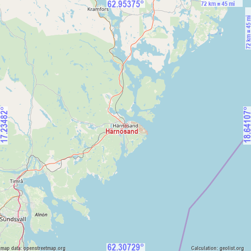
Härnösand GPS coordinates[2]
62° 37' 56.208" North, 17° 56' 16.584" East
| Map corner | latitude | longitude |
|---|---|---|
| Upper-left | 62.95375°, | 17.23482° |
| Center: | 62.63228°, | 17.93794° |
| Lower-right: | 62.30729°, | 18.64107° |
| Map W x H: | 71.9×71.9 km | = 44.7×44.7mi |
| max Lat: | 67.85572° ⇑11.9% North |
| Härnösand: | 62.63228° |
| min Lat: | ⇓88.1% South 55.34337° |
| min Long | Härnösand | max Long |
| 11.1712° | 17.93794° | 24.13676° |
| W 85.1%⇐ | ⇒14.9% E |
Elevation
Elevation of Härnösand is 25 m = 82 ft, and this is 57.6 m = 189 ft below average elevation for this country.
| Max E: |
663 m = 2175 ft | 70% |
| Avg. | 82.6 m = 271 ft | |
| Härnösand | 25 m = 82 ft | |
Min E: |
-1 m = -3 ft | 30% |
See also: Sweden elevation on elevation.city.
Geographical zone
Härnösand is located in North temperate zone (between Tropic of Cancer and the Arctic Circle). Distance of this North polar circle is 437.1 km =271.6 mi to North.| Distance of | km | miles | from Härnösand |
|---|---|---|---|
| North Pole | 3043 | 1890.8 | to North |
| Arctic Circle | 437.1 | 271.6 | to North |
| Tropic Cancer | 4358.1 | 2708 | to South |
| Equator | 6964.1 | 4327.3 | to South |


Nearby cities:
15 places around Härnösand: (largest is in red/bold)
• Ankarsvik
39.7 km =24.7 mi,  222°
222°
• Bergeforsen
30.7 km =19.1 mi,  248°
248°
• Frånö
31 km =19.3 mi,  351°
351°
• Johannedal
36.4 km =22.6 mi,  232°
232°
• Kramfors
34.3 km =21.3 mi, 346°
• Kungsgården
41.2 km =25.6 mi, 352°
• Nyland
42.6 km =26.5 mi, 347°
• Ramvik
21 km =13 mi, 347°
• Sundsbruk
35.9 km =22.3 mi,  237°
237°
• Sundsvall
42.1 km =26.2 mi, 230°
• Svartvik
5.3 km =3.3 mi,  196°
196°
• Söråker
26 km =16.2 mi, 237°
• Timrå
35.3 km =21.9 mi, 242°
• Vi
34.7 km =21.6 mi, 230°
• Älandsbro
7 km =4.3 mi,  315°
315°
Sources, notices
• [Note1] Compared only with cities in Sweden existing in our database
• [Src1] Map data: © OpenStreetMap contributors (CC-BY-SA)
• [Src2] Other city data from geonames.org with taken over terms of usage.
• [Src3] Geographical zone / Annual Mean Temperature by Robert A. Rohde @ Wikipedia
