Gränna geodata
Gränna (Jönköping) is a populated place; located in Sweden in Europe/Stockholm (GMT+1) time zone. With population of 2,726 people, there are 434 cities with bigger population in this country. Compared to other cities in Sweden, 60.4% of cities are located further ↑North; 57.6% of cities are located further →East and 90.3% of cities have lower elevation than Gränna. Note1


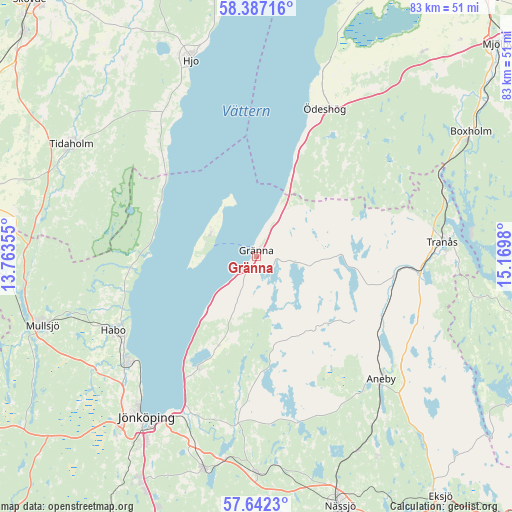
Gränna GPS coordinates[2]
58° 1' 0.012" North, 14° 28' 0.012" East
| Map corner | latitude | longitude |
|---|---|---|
| Upper-left | 58.38716°, | 13.76355° |
| Center: | 58.01667°, | 14.46667° |
| Lower-right: | 57.6423°, | 15.1698° |
| Map W x H: | 82.8×82.8 km | = 51.4×51.4mi |
| max Lat: | 67.85572° ⇑60.4% North |
| Gränna: | 58.01667° |
| min Lat: | ⇓39.6% South 55.34337° |
| min Long | Gränna | max Long |
| 11.1712° | 14.46667° | 24.13676° |
| W 42.4%⇐ | ⇒57.6% E |
Elevation
Elevation of Gränna is 203 m = 666 ft, and this is 120.4 m = 395 ft above average elevation for this country.
| Max E: |
663 m = 2175 ft | 9.7% |
| Gränna | 203 m 666 ft | |
| Avg. | 82.6 m = 271 ft | |
Min E: |
-1 m = -3 ft | 90.3% |
See also: Sweden elevation on elevation.city.
Geographical zone
Gränna is located in North temperate zone (between Tropic of Cancer and the Arctic Circle). Distance of this North polar circle is 950.3 km =590.5 mi to North.| Distance of | km | miles | from Gränna |
|---|---|---|---|
| North Pole | 3556.2 | 2209.7 | to North |
| Arctic Circle | 950.3 | 590.5 | to North |
| Tropic Cancer | 3844.9 | 2389.1 | to South |
| Equator | 6450.8 | 4008.3 | to South |


Nearby cities:
15 places around Gränna: (largest is in red/bold)
• Aneby
28.3 km =17.6 mi,  134°
134°
• Bankeryd
26.7 km =16.6 mi,  229°
229°
• Habo
25.9 km =16.1 mi,  243°
243°
• Hestra
13.1 km =8.1 mi,  148°
148°
• Hjo
33.3 km =20.7 mi,  341°
341°
• Huskvarna
27.4 km =17 mi,  200°
200°
• Jönköping
31.9 km =19.8 mi,  215°
215°
• Kaxholmen
20.5 km =12.7 mi,  207°
207°
• Kortebo
29.1 km =18.1 mi, 220°
• Lekeryd
28.1 km =17.5 mi,  188°
188°
• Ryssby
35.1 km =21.8 mi,  161°
161°
• Sommen
32.1 km =19.9 mi,  66°
66°
• Tidaholm
35 km =21.7 mi,  301°
301°
• Tranås
30.2 km =18.8 mi,  85°
85°
• Ödeshög
26.1 km =16.2 mi,  24°
24°
Sources, notices
• [Note1] Compared only with cities in Sweden existing in our database
• [Src1] Map data: © OpenStreetMap contributors (CC-BY-SA)
• [Src2] Other city data from geonames.org with taken over terms of usage.
• [Src3] Geographical zone / Annual Mean Temperature by Robert A. Rohde @ Wikipedia
