Järna geodata
Järna (Stockholm) is a populated place; located in Sweden in Europe/Stockholm (GMT+2) time zone. With population of 6,038 people, there are 232 cities with bigger population in this country. Compared to other cities in Sweden, 55.1% of cities are located further ↓South; 80.2% of cities are located further ←West and 55.2% of cities have higher elevation than Järna. Note1
Administrative division(s):
- Level 1: Stockholm
- Level 2: Södertälje Kommun
- Level 3: Överjärna
- Level 4: Överjärna socken


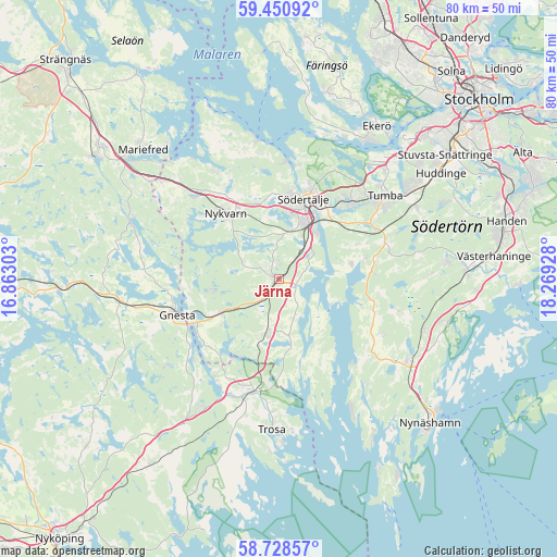
Järna GPS coordinates[2]
59° 5' 29.94" North, 17° 33' 58.14" East
| Map corner | latitude | longitude |
|---|---|---|
| Upper-left | 59.45092°, | 16.86303° |
| Center: | 59.09165°, | 17.56615° |
| Lower-right: | 58.72857°, | 18.26928° |
| Map W x H: | 80.3×80.3 km | = 49.9×49.9mi |
| max Lat: | 67.85572° ⇑44.9% North |
| Järna: | 59.09165° |
| min Lat: | ⇓55.1% South 55.34337° |
| min Long | Järna | max Long |
| 11.1712° | 17.56615° | 24.13676° |
| W 80.2%⇐ | ⇒19.8% E |
Elevation
Elevation of Järna is 42 m = 138 ft, and this is 40.6 m = 133 ft below average elevation for this country.
| Max E: |
663 m = 2175 ft | 55.2% |
| Avg. | 82.6 m = 271 ft | |
| Järna | 42 m = 138 ft | |
Min E: |
-1 m = -3 ft | 44.8% |
See also: Sweden elevation on elevation.city.
Geographical zone
Järna is located in North temperate zone (between Tropic of Cancer and the Arctic Circle). Distance of this North polar circle is 830.8 km =516.2 mi to North.| Distance of | km | miles | from Järna |
|---|---|---|---|
| North Pole | 3436.7 | 2135.5 | to North |
| Arctic Circle | 830.8 | 516.2 | to North |
| Tropic Cancer | 3964.5 | 2463.4 | to South |
| Equator | 6570.4 | 4082.7 | to South |


Nearby cities:
15 places around Järna: (largest is in red/bold)
• Ekeby
17.8 km =11.1 mi,  351°
351°
• Gnesta
15.3 km =9.5 mi,  251°
251°
• Grödby
18.7 km =11.6 mi,  104°
104°
• Hölö
8.5 km =5.3 mi,  192°
192°
• Mölnbo
9.7 km =6 mi,  241°
241°
• Nykvarn
12.2 km =7.6 mi,  321°
321°
• Pershagen
8.6 km =5.3 mi,  35°
35°
• Rönninge
15.4 km =9.6 mi, 38°
• Stora Vika
19.7 km =12.2 mi,  140°
140°
• Södertälje
12 km =7.5 mi,  16°
16°
• Trosa
21.8 km =13.5 mi,  182°
182°
• Tumba
19.3 km =12 mi,  52°
52°
• Vagnhärad
16.8 km =10.4 mi,  195°
195°
• Viksäter
16.8 km =10.4 mi,  9°
9°
• Vårsta
15.5 km =9.6 mi,  58°
58°
Sources, notices
• [Note1] Compared only with cities in Sweden existing in our database
• [Src1] Map data: © OpenStreetMap contributors (CC-BY-SA)
• [Src2] Other city data from geonames.org with taken over terms of usage.
• [Src3] Geographical zone / Annual Mean Temperature by Robert A. Rohde @ Wikipedia
