Trosa geodata
Trosa (Södermanland) is a seat of a second-order administrative division; located in Sweden in Europe/Stockholm (GMT+2) time zone. With population of 5,836 people, there are 244 cities with bigger population in this country. Compared to other cities in Sweden, 52.2% of cities are located further ↓South; 80.1% of cities are located further ←West and 91.5% of cities have higher elevation than Trosa. Note1


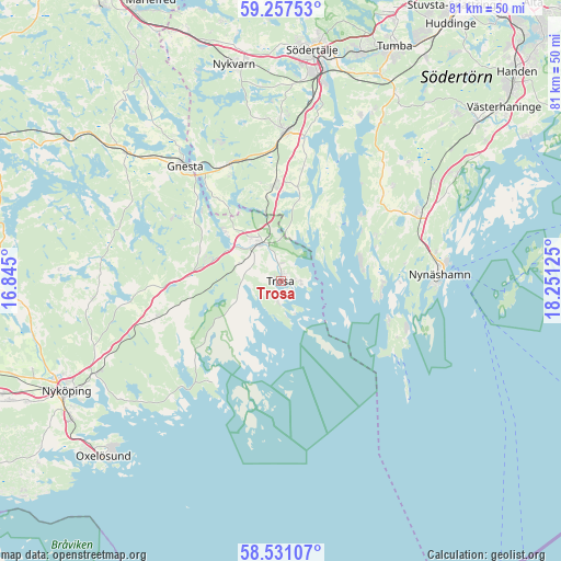
Trosa GPS coordinates[2]
58° 53' 46.356" North, 17° 32' 53.232" East
| Map corner | latitude | longitude |
|---|---|---|
| Upper-left | 59.25753°, | 16.845° |
| Center: | 58.89621°, | 17.54812° |
| Lower-right: | 58.53107°, | 18.25125° |
| Map W x H: | 80.8×80.8 km | = 50.2×50.2mi |
| max Lat: | 67.85572° ⇑47.8% North |
| Trosa: | 58.89621° |
| min Lat: | ⇓52.2% South 55.34337° |
| min Long | Trosa | max Long |
| 11.1712° | 17.54812° | 24.13676° |
| W 80.1%⇐ | ⇒19.9% E |
Elevation
Elevation of Trosa is 8 m = 26 ft, and this is 74.6 m = 245 ft below average elevation for this country.
| Max E: |
663 m = 2175 ft | 91.5% |
| Avg. | 82.6 m = 271 ft | |
| Trosa | 8 m = 26 ft | |
Min E: |
-1 m = -3 ft | 8.5% |
See also: Sweden elevation on elevation.city.
Geographical zone
Trosa is located in North temperate zone (between Tropic of Cancer and the Arctic Circle). Distance of this North polar circle is 852.5 km =529.7 mi to North.| Distance of | km | miles | from Trosa |
|---|---|---|---|
| North Pole | 3458.4 | 2148.9 | to North |
| Arctic Circle | 852.5 | 529.7 | to North |
| Tropic Cancer | 3942.7 | 2449.9 | to South |
| Equator | 6548.6 | 4069.1 | to South |


Nearby cities:
15 places around Trosa: (largest is in red/bold)
• Björnlunda
29.1 km =18.1 mi,  310°
310°
• Gnesta
21.6 km =13.4 mi,  321°
321°
• Grödby
25.7 km =16 mi,  48°
48°
• Hölö
13.4 km =8.3 mi,  356°
356°
• Järna
21.8 km =13.5 mi,  2°
2°
• Mölnbo
18.7 km =11.6 mi,  336°
336°
• Nykvarn
31.9 km =19.8 mi,  348°
348°
• Nynäshamn
23 km =14.3 mi,  88°
88°
• Pershagen
29.4 km =18.3 mi,  11°
11°
• Segersäng
26.5 km =16.5 mi,  56°
56°
• Stora Vika
15.2 km =9.4 mi, 64°
• Tystberga
18.8 km =11.7 mi,  254°
254°
• Vagnhärad
6.5 km =4 mi,  327°
327°
• Vårsta
33.1 km =20.6 mi,  25°
25°
• Ösmo
22.4 km =13.9 mi, 64°
Sources, notices
• [Note1] Compared only with cities in Sweden existing in our database
• [Src1] Map data: © OpenStreetMap contributors (CC-BY-SA)
• [Src2] Other city data from geonames.org with taken over terms of usage.
• [Src3] Geographical zone / Annual Mean Temperature by Robert A. Rohde @ Wikipedia
