Järlåsa geodata
Järlåsa (Uppsala) is a populated place; located in Sweden in Europe/Stockholm (GMT+2) time zone. With population of 515 people, there are 1294 cities with bigger population in this country. Compared to other cities in Sweden, 72% of cities are located further ↓South; 76.3% of cities are located further ←West and 61.7% of cities have lower elevation than Järlåsa. Note1


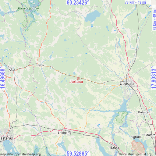
Järlåsa GPS coordinates[2]
59° 52' 59.988" North, 17° 12' 0" East
| Map corner | latitude | longitude |
|---|---|---|
| Upper-left | 60.23426°, | 16.49688° |
| Center: | 59.88333°, | 17.2° |
| Lower-right: | 59.52865°, | 17.90313° |
| Map W x H: | 78.5×78.5 km | = 48.8×48.8mi |
| max Lat: | 67.85572° ⇑28% North |
| Järlåsa: | 59.88333° |
| min Lat: | ⇓72% South 55.34337° |
| min Long | Järlåsa | max Long |
| 11.1712° | 17.2° | 24.13676° |
| W 76.3%⇐ | ⇒23.7% E |
Elevation
Elevation of Järlåsa is 74 m = 243 ft, and this is 8.6 m = 28 ft below average elevation for this country.
| Max E: |
663 m = 2175 ft | 38.3% |
| Avg. | 82.6 m = 271 ft | |
| Järlåsa | 74 m = 243 ft | |
Min E: |
-1 m = -3 ft | 61.7% |
See also: Sweden elevation on elevation.city.
Geographical zone
Järlåsa is located in North temperate zone (between Tropic of Cancer and the Arctic Circle). Distance of this North polar circle is 742.8 km =461.6 mi to North.| Distance of | km | miles | from Järlåsa |
|---|---|---|---|
| North Pole | 3348.7 | 2080.8 | to North |
| Arctic Circle | 742.8 | 461.6 | to North |
| Tropic Cancer | 4052.5 | 2518.1 | to South |
| Equator | 6658.4 | 4137.3 | to South |


Nearby cities:
15 places around Järlåsa: (largest is in red/bold)
• Björklinge
25.5 km =15.8 mi,  50°
50°
• Bälinge
20 km =12.4 mi,  68°
68°
• Fjärdhundra
19.7 km =12.2 mi,  232°
232°
• Gamla Uppsala
24.3 km =15.1 mi,  86°
86°
• Hagby
13.1 km =8.1 mi,  134°
134°
• Harbo
24.1 km =15 mi,  0°
0°
• Heby
19.8 km =12.3 mi,  287°
287°
• Irsta
25.3 km =15.7 mi,  216°
216°
• Lövstalöt
22.6 km =14 mi, 68°
• Morgongåva
14.3 km =8.9 mi, 293°
• Uppsala
24.6 km =15.3 mi,  96°
96°
• Viby
24.1 km =15 mi, 0°
• Vittinge
7.7 km =4.8 mi,  283°
283°
• Ytternäs
25 km =15.5 mi,  116°
116°
• Örsundsbro
17.6 km =10.9 mi,  161°
161°
Sources, notices
• [Note1] Compared only with cities in Sweden existing in our database
• [Src1] Map data: © OpenStreetMap contributors (CC-BY-SA)
• [Src2] Other city data from geonames.org with taken over terms of usage.
• [Src3] Geographical zone / Annual Mean Temperature by Robert A. Rohde @ Wikipedia
