Morgongåva geodata
Morgongåva (Uppsala) is a populated place; located in Sweden in Europe/Stockholm (GMT+2) time zone. With population of 1,441 people, there are 676 cities with bigger population in this country. Compared to other cities in Sweden, 72.8% of cities are located further ↓South; 73.1% of cities are located further ←West and 62.3% of cities have lower elevation than Morgongåva. Note1
Administrative division(s):
- Level 1: Uppsala
- Level 2: Heby kommun
- Level 3: Vittinge
- Level 4: Vittinge socken


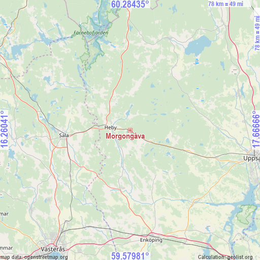
Morgongåva GPS coordinates[2]
59° 56' 2.22" North, 16° 57' 48.708" East
| Map corner | latitude | longitude |
|---|---|---|
| Upper-left | 60.28435°, | 16.26041° |
| Center: | 59.93395°, | 16.96353° |
| Lower-right: | 59.57981°, | 17.66666° |
| Map W x H: | 78.3×78.3 km | = 48.7×48.7mi |
| max Lat: | 67.85572° ⇑27.2% North |
| Morgongåva: | 59.93395° |
| min Lat: | ⇓72.8% South 55.34337° |
| min Long | Morgongåva | max Long |
| 11.1712° | 16.96353° | 24.13676° |
| W 73.1%⇐ | ⇒26.9% E |
Elevation
Elevation of Morgongåva is 75 m = 246 ft, and this is 7.6 m = 25 ft below average elevation for this country.
| Max E: |
663 m = 2175 ft | 37.7% |
| Avg. | 82.6 m = 271 ft | |
| Morgongåva | 75 m = 246 ft | |
Min E: |
-1 m = -3 ft | 62.3% |
See also: Sweden elevation on elevation.city.
Geographical zone
Morgongåva is located in North temperate zone (between Tropic of Cancer and the Arctic Circle). Distance of this North polar circle is 737.1 km =458 mi to North.| Distance of | km | miles | from Morgongåva |
|---|---|---|---|
| North Pole | 3343 | 2077.2 | to North |
| Arctic Circle | 737.1 | 458 | to North |
| Tropic Cancer | 4058.1 | 2521.6 | to South |
| Equator | 6664 | 4140.8 | to South |


Nearby cities:
15 places around Morgongåva: (largest is in red/bold)
• Bälinge
31.8 km =19.8 mi,  86°
86°
• Enköping
33.7 km =20.9 mi,  169°
169°
• Fjärdhundra
17.8 km =11.1 mi,  187°
187°
• Hagby
27 km =16.8 mi,  123°
123°
• Harbo
22.7 km =14.1 mi,  35°
35°
• Heby
5.7 km =3.5 mi,  274°
274°
• Irsta
26.1 km =16.2 mi,  183°
183°
• Järlåsa
14.3 km =8.9 mi,  113°
113°
• Ransta
22.8 km =14.2 mi,  232°
232°
• Sala
20 km =12.4 mi, 265°
• Tärnsjö
24.1 km =15 mi,  356°
356°
• Viby
22.7 km =14.1 mi, 35°
• Vittinge
6.9 km =4.3 mi, 123°
• Örsundsbro
29.2 km =18.1 mi,  139°
139°
• Östervåla
30.3 km =18.8 mi,  23°
23°
Sources, notices
• [Note1] Compared only with cities in Sweden existing in our database
• [Src1] Map data: © OpenStreetMap contributors (CC-BY-SA)
• [Src2] Other city data from geonames.org with taken over terms of usage.
• [Src3] Geographical zone / Annual Mean Temperature by Robert A. Rohde @ Wikipedia
