Gamla Uppsala geodata
Gamla Uppsala (Uppsala) is a section of populated place; located in Sweden in Europe/Stockholm (GMT+2) time zone. With population of 16,231 people, there are 97 cities with bigger population in this country. Compared to other cities in Sweden, 72.3% of cities are located further ↓South; 80.9% of cities are located further ←West and 61.1% of cities have higher elevation than Gamla Uppsala. Note1
Administrative division(s):
- Level 1: Uppsala
- Level 2: Uppsala Kommun
- Level 3: Uppsala domkyrkoförs.
- Level 4: Uppsala socken


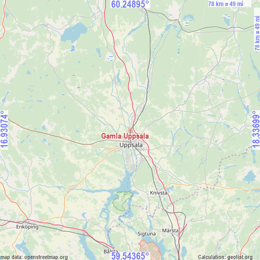
Gamla Uppsala GPS coordinates[2]
59° 53' 53.412" North, 17° 38' 1.896" East
| Map corner | latitude | longitude |
|---|---|---|
| Upper-left | 60.24895°, | 16.93074° |
| Center: | 59.89817°, | 17.63386° |
| Lower-right: | 59.54365°, | 18.33699° |
| Map W x H: | 78.4×78.4 km | = 48.7×48.7mi |
| max Lat: | 67.85572° ⇑27.7% North |
| Gamla Uppsala: | 59.89817° |
| min Lat: | ⇓72.3% South 55.34337° |
| min Long | Gamla Uppsala | max Long |
| 11.1712° | 17.63386° | 24.13676° |
| W 80.9%⇐ | ⇒19.1% E |
Elevation
Elevation of Gamla Uppsala is 34 m = 112 ft, and this is 48.6 m = 159 ft below average elevation for this country.
| Max E: |
663 m = 2175 ft | 61.1% |
| Avg. | 82.6 m = 271 ft | |
| Gamla Uppsala | 34 m = 112 ft | |
Min E: |
-1 m = -3 ft | 38.9% |
See also: Sweden elevation on elevation.city.
Geographical zone
Gamla Uppsala is located in North temperate zone (between Tropic of Cancer and the Arctic Circle). Distance of this North polar circle is 741.1 km =460.5 mi to North.| Distance of | km | miles | from Gamla Uppsala |
|---|---|---|---|
| North Pole | 3347 | 2079.7 | to North |
| Arctic Circle | 741.1 | 460.5 | to North |
| Tropic Cancer | 4054.1 | 2519.1 | to South |
| Equator | 6660.1 | 4138.4 | to South |


Nearby cities:
15 places around Gamla Uppsala: (largest is in red/bold)
• Alsike
17.9 km =11.1 mi,  154°
154°
• Björklinge
15.4 km =9.6 mi,  342°
342°
• Bälinge
8 km =5 mi,  315°
315°
• Gunsta
12.4 km =7.7 mi,  115°
115°
• Gåvsta
14.5 km =9 mi,  69°
69°
• Hagby
18.5 km =11.5 mi,  233°
233°
• Knivsta
21 km =13 mi,  155°
155°
• Länna
18 km =11.2 mi,  99°
99°
• Lövstalöt
7.3 km =4.5 mi,  334°
334°
• Skyttorp
21.3 km =13.2 mi,  15°
15°
• Storvreta
7.9 km =4.9 mi,  30°
30°
• Sävja
9.6 km =6 mi, 157°
• Uppsala
4.4 km =2.7 mi,  176°
176°
• Vattholma
14.3 km =8.9 mi, 22°
• Ytternäs
12.9 km =8 mi,  188°
188°
Sources, notices
• [Note1] Compared only with cities in Sweden existing in our database
• [Src1] Map data: © OpenStreetMap contributors (CC-BY-SA)
• [Src2] Other city data from geonames.org with taken over terms of usage.
• [Src3] Geographical zone / Annual Mean Temperature by Robert A. Rohde @ Wikipedia
