Fjärdhundra geodata
Fjärdhundra (Uppsala) is a populated place; located in Sweden in Europe/Stockholm (GMT+2) time zone. With population of 907 people, there are 878 cities with bigger population in this country. Compared to other cities in Sweden, 70.9% of cities are located further ↓South; 72.8% of cities are located further ←West and 51.1% of cities have higher elevation than Fjärdhundra. Note1


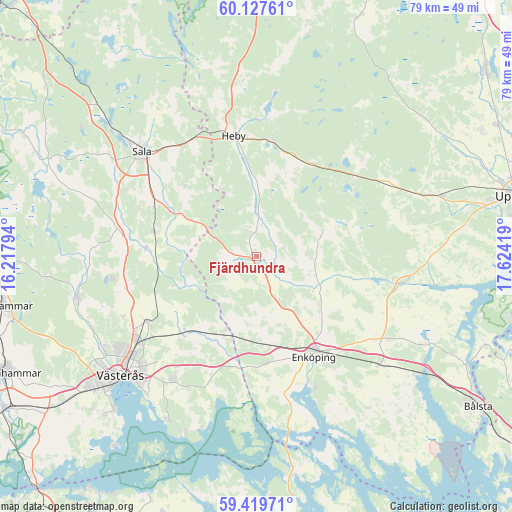
Fjärdhundra GPS coordinates[2]
59° 46' 31.944" North, 16° 55' 15.816" East
| Map corner | latitude | longitude |
|---|---|---|
| Upper-left | 60.12761°, | 16.21794° |
| Center: | 59.77554°, | 16.92106° |
| Lower-right: | 59.41971°, | 17.62419° |
| Map W x H: | 78.7×78.7 km | = 48.9×48.9mi |
| max Lat: | 67.85572° ⇑29.1% North |
| Fjärdhundra: | 59.77554° |
| min Lat: | ⇓70.9% South 55.34337° |
| min Long | Fjärdhundra | max Long |
| 11.1712° | 16.92106° | 24.13676° |
| W 72.8%⇐ | ⇒27.2% E |
Elevation
Elevation of Fjärdhundra is 48 m = 157 ft, and this is 34.6 m = 114 ft below average elevation for this country.
| Max E: |
663 m = 2175 ft | 51.1% |
| Avg. | 82.6 m = 271 ft | |
| Fjärdhundra | 48 m = 157 ft | |
Min E: |
-1 m = -3 ft | 48.9% |
See also: Sweden elevation on elevation.city.
Geographical zone
Fjärdhundra is located in North temperate zone (between Tropic of Cancer and the Arctic Circle). Distance of this North polar circle is 754.8 km =469 mi to North.| Distance of | km | miles | from Fjärdhundra |
|---|---|---|---|
| North Pole | 3360.6 | 2088.2 | to North |
| Arctic Circle | 754.8 | 469 | to North |
| Tropic Cancer | 4040.5 | 2510.6 | to South |
| Equator | 6646.4 | 4129.9 | to South |


Nearby cities:
15 places around Fjärdhundra: (largest is in red/bold)
• Bredsand
22.9 km =14.2 mi,  159°
159°
• Enköping
17.8 km =11.1 mi,  150°
150°
• Hagby
25.1 km =15.6 mi,  83°
83°
• Heby
18.4 km =11.4 mi,  349°
349°
• Hummelsta
16.6 km =10.3 mi,  175°
175°
• Hökåsen
22.5 km =14 mi,  237°
237°
• Irsta
8.4 km =5.2 mi, 175°
• Irsta
23.1 km =14.4 mi,  212°
212°
• Järlåsa
19.7 km =12.2 mi,  52°
52°
• Morgongåva
17.8 km =11.1 mi,  7°
7°
• Ransta
16.3 km =10.1 mi,  283°
283°
• Sala
23.8 km =14.8 mi,  312°
312°
• Tillberga
19.9 km =12.4 mi, 238°
• Vittinge
16.1 km =10 mi,  30°
30°
• Örsundsbro
21.7 km =13.5 mi,  102°
102°
Sources, notices
• [Note1] Compared only with cities in Sweden existing in our database
• [Src1] Map data: © OpenStreetMap contributors (CC-BY-SA)
• [Src2] Other city data from geonames.org with taken over terms of usage.
• [Src3] Geographical zone / Annual Mean Temperature by Robert A. Rohde @ Wikipedia
