Grundsund geodata
Grundsund (Västra Götaland) is a populated place; located in Sweden in Europe/Stockholm (GMT+2) time zone. With population of 647 people, there are 1126 cities with bigger population in this country. Compared to other cities in Sweden, 57.7% of cities are located further ↑North; 99.2% of cities are located further →East and 96.4% of cities have higher elevation than Grundsund. Note1


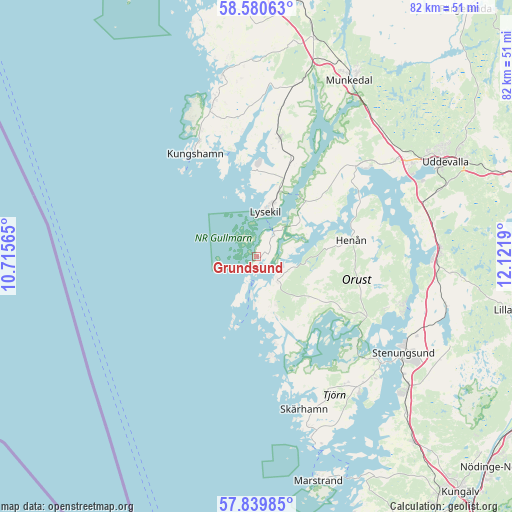
Grundsund GPS coordinates[2]
58° 12' 43.812" North, 11° 25' 7.572" East
| Map corner | latitude | longitude |
|---|---|---|
| Upper-left | 58.58063°, | 10.71565° |
| Center: | 58.21217°, | 11.41877° |
| Lower-right: | 57.83985°, | 12.1219° |
| Map W x H: | 82.4×82.4 km | = 51.2×51.2mi |
| max Lat: | 67.85572° ⇑57.7% North |
| Grundsund: | 58.21217° |
| min Lat: | ⇓42.3% South 55.34337° |
| min Long | Grundsund | max Long |
| 11.1712° | 11.41877° | 24.13676° |
| W 0.8%⇐ | ⇒99.2% E |
Elevation
Elevation of Grundsund is 4 m = 13 ft, and this is 78.6 m = 258 ft below average elevation for this country.
| Max E: |
663 m = 2175 ft | 96.4% |
| Avg. | 82.6 m = 271 ft | |
| Grundsund | 4 m = 13 ft | |
Min E: |
-1 m = -3 ft | 3.6% |
See also: Sweden elevation on elevation.city.
Geographical zone
Grundsund is located in North temperate zone (between Tropic of Cancer and the Arctic Circle). Distance of this North polar circle is 928.6 km =577 mi to North.| Distance of | km | miles | from Grundsund |
|---|---|---|---|
| North Pole | 3534.5 | 2196.2 | to North |
| Arctic Circle | 928.6 | 577 | to North |
| Tropic Cancer | 3866.7 | 2402.7 | to South |
| Equator | 6472.6 | 4021.9 | to South |


Nearby cities:
15 places around Grundsund: (largest is in red/bold)
• Ammenäs
26.4 km =16.4 mi,  64°
64°
• Brastad
19.4 km =12.1 mi,  11°
11°
• Ellös
4.3 km =2.7 mi,  138°
138°
• Henån
15.3 km =9.5 mi,  79°
79°
• Hunnebostrand
26.4 km =16.4 mi,  345°
345°
• Klövedal
22.1 km =13.7 mi,  154°
154°
• Kungshamn
19.2 km =11.9 mi,  330°
330°
• Kyrkesund
22.5 km =14 mi,  165°
165°
• Lysekil
7 km =4.3 mi, 8°
• Myggenäs
25.6 km =15.9 mi,  130°
130°
• Skärhamn
26.4 km =16.4 mi,  162°
162°
• Smögen
19.6 km =12.2 mi,  324°
324°
• Svanesund
24.7 km =15.3 mi,  108°
108°
• Varekil
19.6 km =12.2 mi,  120°
120°
• Väjern
21 km =13 mi, 334°
Sources, notices
• [Note1] Compared only with cities in Sweden existing in our database
• [Src1] Map data: © OpenStreetMap contributors (CC-BY-SA)
• [Src2] Other city data from geonames.org with taken over terms of usage.
• [Src3] Geographical zone / Annual Mean Temperature by Robert A. Rohde @ Wikipedia
