Hjo geodata
Hjo (Västra Götaland) is a seat of a second-order administrative division; located in Sweden in Europe/Stockholm (GMT+2) time zone. With population of 6,203 people, there are 227 cities with bigger population in this country. Compared to other cities in Sweden, 56.6% of cities are located further ↑North; 59.4% of cities are located further →East and 69.9% of cities have lower elevation than Hjo. Note1


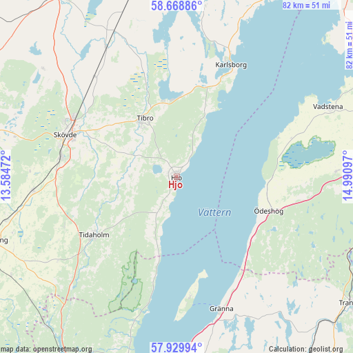
Hjo GPS coordinates[2]
58° 18' 4.788" North, 14° 17' 16.224" East
| Map corner | latitude | longitude |
|---|---|---|
| Upper-left | 58.66886°, | 13.58472° |
| Center: | 58.30133°, | 14.28784° |
| Lower-right: | 57.92994°, | 14.99097° |
| Map W x H: | 82.2×82.2 km | = 51.1×51.1mi |
| max Lat: | 67.85572° ⇑56.6% North |
| Hjo: | 58.30133° |
| min Lat: | ⇓43.4% South 55.34337° |
| min Long | Hjo | max Long |
| 11.1712° | 14.28784° | 24.13676° |
| W 40.6%⇐ | ⇒59.4% E |
Elevation
Elevation of Hjo is 98 m = 322 ft, and this is 15.4 m = 51 ft above average elevation for this country.
| Max E: |
663 m = 2175 ft | 30.1% |
| Hjo | 98 m 322 ft | |
| Avg. | 82.6 m = 271 ft | |
Min E: |
-1 m = -3 ft | 69.9% |
See also: Sweden elevation on elevation.city.
Geographical zone
Hjo is located in North temperate zone (between Tropic of Cancer and the Arctic Circle). Distance of this North polar circle is 918.7 km =570.9 mi to North.| Distance of | km | miles | from Hjo |
|---|---|---|---|
| North Pole | 3524.6 | 2190.1 | to North |
| Arctic Circle | 918.7 | 570.9 | to North |
| Tropic Cancer | 3876.6 | 2408.8 | to South |
| Equator | 6482.5 | 4028 | to South |


Nearby cities:
15 places around Hjo: (largest is in red/bold)
• Fagersanna
18.4 km =11.4 mi,  2°
2°
• Gränna
33.3 km =20.7 mi,  161°
161°
• Herrestad
31.2 km =19.4 mi,  73°
73°
• Igelstorp
21.7 km =13.5 mi,  300°
300°
• Karlsborg
29.1 km =18.1 mi,  25°
25°
• Mölltorp
23 km =14.3 mi,  16°
16°
• Olofstorp
17.8 km =11.1 mi,  251°
251°
• Skultorp
27.1 km =16.8 mi,  281°
281°
• Skövde
27.7 km =17.2 mi,  291°
291°
• Stöpen
31.5 km =19.6 mi,  308°
308°
• Tibro
15.6 km =9.7 mi,  331°
331°
• Tidaholm
23.5 km =14.6 mi,  235°
235°
• Väring
29.3 km =18.2 mi,  320°
320°
• Värsås
14.9 km =9.3 mi, 291°
• Ödeshög
22.8 km =14.2 mi,  110°
110°
Sources, notices
• [Note1] Compared only with cities in Sweden existing in our database
• [Src1] Map data: © OpenStreetMap contributors (CC-BY-SA)
• [Src2] Other city data from geonames.org with taken over terms of usage.
• [Src3] Geographical zone / Annual Mean Temperature by Robert A. Rohde @ Wikipedia
