Gislaved geodata
Gislaved (Jönköping) is a seat of a second-order administrative division; located in Sweden in Europe/Stockholm (GMT+2) time zone. With population of 10,180 people, there are 148 cities with bigger population in this country. Compared to other cities in Sweden, 74.7% of cities are located further ↑North; 70.5% of cities are located further →East and 84.8% of cities have lower elevation than Gislaved. Note1


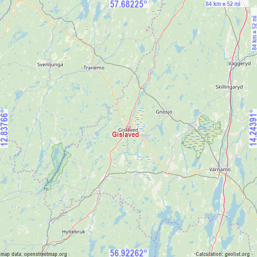
Gislaved GPS coordinates[2]
57° 18' 15.84" North, 13° 32' 26.808" East
| Map corner | latitude | longitude |
|---|---|---|
| Upper-left | 57.68225°, | 12.83766° |
| Center: | 57.3044°, | 13.54078° |
| Lower-right: | 56.92262°, | 14.24391° |
| Map W x H: | 84.5×84.5 km | = 52.5×52.5mi |
| max Lat: | 67.85572° ⇑74.7% North |
| Gislaved: | 57.3044° |
| min Lat: | ⇓25.3% South 55.34337° |
| min Long | Gislaved | max Long |
| 11.1712° | 13.54078° | 24.13676° |
| W 29.5%⇐ | ⇒70.5% E |
Elevation
Elevation of Gislaved is 167 m = 548 ft, and this is 84.4 m = 277 ft above average elevation for this country.
| Max E: |
663 m = 2175 ft | 15.2% |
| Gislaved | 167 m 548 ft | |
| Avg. | 82.6 m = 271 ft | |
Min E: |
-1 m = -3 ft | 84.8% |
See also: Sweden elevation on elevation.city.
Geographical zone
Gislaved is located in North temperate zone (between Tropic of Cancer and the Arctic Circle). Distance of this North polar circle is 1029.5 km =639.7 mi to North.| Distance of | km | miles | from Gislaved |
|---|---|---|---|
| North Pole | 3635.4 | 2258.9 | to North |
| Arctic Circle | 1029.5 | 639.7 | to North |
| Tropic Cancer | 3765.7 | 2339.9 | to South |
| Equator | 6371.7 | 3959.2 | to South |


Nearby cities:
15 places around Gislaved: (largest is in red/bold)
• Anderstorp
6 km =3.7 mi,  112°
112°
• Bredaryd
18.8 km =11.7 mi,  140°
140°
• Burseryd
19.4 km =12.1 mi,  233°
233°
• Dalstorp
33.3 km =20.7 mi,  358°
358°
• Forsheda
23.4 km =14.5 mi,  131°
131°
• Gnosjö
13.2 km =8.2 mi,  62°
62°
• Grimsås
20 km =12.4 mi,  1°
1°
• Hestra
15.7 km =9.8 mi,  12°
12°
• Hillerstorp
20.7 km =12.9 mi,  87°
87°
• Limmared
28 km =17.4 mi,  336°
336°
• Marieholm
20.5 km =12.7 mi, 64°
• Reftele
14.8 km =9.2 mi,  167°
167°
• Smålandsstenar
17.6 km =10.9 mi,  206°
206°
• Tranemo
22.9 km =14.2 mi,  330°
330°
• Värnamo
32.8 km =20.4 mi, 113°
Sources, notices
• [Note1] Compared only with cities in Sweden existing in our database
• [Src1] Map data: © OpenStreetMap contributors (CC-BY-SA)
• [Src2] Other city data from geonames.org with taken over terms of usage.
• [Src3] Geographical zone / Annual Mean Temperature by Robert A. Rohde @ Wikipedia
