Dalstorp geodata
Dalstorp (Västra Götaland) is a populated place; located in Sweden in Europe/Stockholm (GMT+2) time zone. With population of 734 people, there are 1027 cities with bigger population in this country. Compared to other cities in Sweden, 70.2% of cities are located further ↑North; 70.8% of cities are located further →East and 90% of cities have lower elevation than Dalstorp. Note1


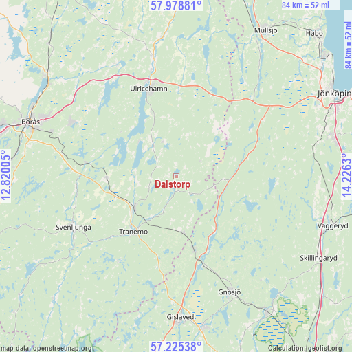
Dalstorp GPS coordinates[2]
57° 36' 14.58" North, 13° 31' 23.412" East
| Map corner | latitude | longitude |
|---|---|---|
| Upper-left | 57.97881°, | 12.82005° |
| Center: | 57.60405°, | 13.52317° |
| Lower-right: | 57.22538°, | 14.2263° |
| Map W x H: | 83.8×83.8 km | = 52.1×52.1mi |
| max Lat: | 67.85572° ⇑70.2% North |
| Dalstorp: | 57.60405° |
| min Lat: | ⇓29.8% South 55.34337° |
| min Long | Dalstorp | max Long |
| 11.1712° | 13.52317° | 24.13676° |
| W 29.2%⇐ | ⇒70.8% E |
Elevation
Elevation of Dalstorp is 202 m = 663 ft, and this is 119.4 m = 392 ft above average elevation for this country.
| Max E: |
663 m = 2175 ft | 10% |
| Dalstorp | 202 m 663 ft | |
| Avg. | 82.6 m = 271 ft | |
Min E: |
-1 m = -3 ft | 90% |
See also: Sweden elevation on elevation.city.
Geographical zone
Dalstorp is located in North temperate zone (between Tropic of Cancer and the Arctic Circle). Distance of this North polar circle is 996.2 km =619 mi to North.| Distance of | km | miles | from Dalstorp |
|---|---|---|---|
| North Pole | 3602.1 | 2238.2 | to North |
| Arctic Circle | 996.2 | 619 | to North |
| Tropic Cancer | 3799.1 | 2360.7 | to South |
| Equator | 6405 | 3979.9 | to South |


Nearby cities:
15 places around Dalstorp: (largest is in red/bold)
• Bottnaryd
25.9 km =16.1 mi,  43°
43°
• Dalsjöfors
29 km =18 mi,  295°
295°
• Grimsås
13.5 km =8.4 mi,  173°
173°
• Gällstad
8.8 km =5.5 mi,  322°
322°
• Hestra
18.5 km =11.5 mi, 166°
• Hillared
22.5 km =14 mi,  278°
278°
• Limmared
12.5 km =7.8 mi,  232°
232°
• Länghem
17.3 km =10.7 mi,  268°
268°
• Målsryd
29.5 km =18.3 mi,  287°
287°
• Sexdrega
24.3 km =15.1 mi,  264°
264°
• Svenljunga
27.4 km =17 mi,  243°
243°
• Timmele
28.9 km =18 mi,  348°
348°
• Tranemo
16.9 km =10.5 mi,  217°
217°
• Ulricehamn
21.8 km =13.5 mi,  342°
342°
• Vegby
12.1 km =7.5 mi, 316°
Sources, notices
• [Note1] Compared only with cities in Sweden existing in our database
• [Src1] Map data: © OpenStreetMap contributors (CC-BY-SA)
• [Src2] Other city data from geonames.org with taken over terms of usage.
• [Src3] Geographical zone / Annual Mean Temperature by Robert A. Rohde @ Wikipedia
