Bredaryd geodata
Bredaryd (Jönköping) is a populated place; located in Sweden in Europe/Stockholm (GMT+2) time zone. With population of 1,549 people, there are 644 cities with bigger population in this country. Compared to other cities in Sweden, 76% of cities are located further ↑North; 67.2% of cities are located further →East and 84.3% of cities have lower elevation than Bredaryd. Note1
Administrative division(s):
- Level 1: Jönköping
- Level 2: Värnamo Kommun
- Level 3: Bredaryd
- Level 4: Bredaryd socken


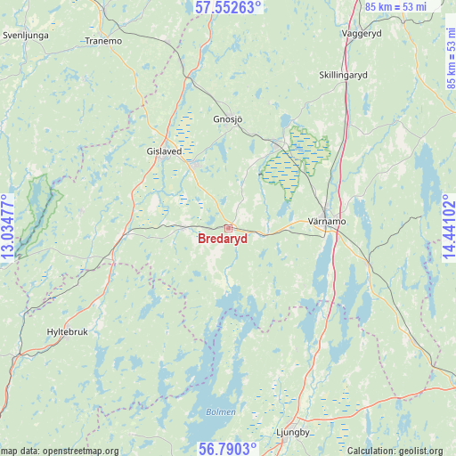
Bredaryd GPS coordinates[2]
57° 10' 24.348" North, 13° 44' 16.404" East
| Map corner | latitude | longitude |
|---|---|---|
| Upper-left | 57.55263°, | 13.03477° |
| Center: | 57.17343°, | 13.73789° |
| Lower-right: | 56.7903°, | 14.44102° |
| Map W x H: | 84.8×84.8 km | = 52.7×52.7mi |
| max Lat: | 67.85572° ⇑76% North |
| Bredaryd: | 57.17343° |
| min Lat: | ⇓24% South 55.34337° |
| min Long | Bredaryd | max Long |
| 11.1712° | 13.73789° | 24.13676° |
| W 32.8%⇐ | ⇒67.2% E |
Elevation
Elevation of Bredaryd is 165 m = 541 ft, and this is 82.4 m = 270 ft above average elevation for this country.
| Max E: |
663 m = 2175 ft | 15.7% |
| Bredaryd | 165 m 541 ft | |
| Avg. | 82.6 m = 271 ft | |
Min E: |
-1 m = -3 ft | 84.3% |
See also: Sweden elevation on elevation.city.
Geographical zone
Bredaryd is located in North temperate zone (between Tropic of Cancer and the Arctic Circle). Distance of this North polar circle is 1044.1 km =648.8 mi to North.| Distance of | km | miles | from Bredaryd |
|---|---|---|---|
| North Pole | 3650 | 2268 | to North |
| Arctic Circle | 1044.1 | 648.8 | to North |
| Tropic Cancer | 3751.2 | 2330.9 | to South |
| Equator | 6357.1 | 3950.1 | to South |


Nearby cities:
15 places around Bredaryd: (largest is in red/bold)
• Anderstorp
13.7 km =8.5 mi,  332°
332°
• Bor
26.6 km =16.5 mi,  103°
103°
• Burseryd
27.5 km =17.1 mi,  276°
276°
• Forsheda
5.7 km =3.5 mi, 100°
• Gislaved
18.8 km =11.7 mi,  320°
320°
• Gnosjö
20.6 km =12.8 mi,  359°
359°
• Hestra
31.1 km =19.3 mi,  344°
344°
• Hillerstorp
17.8 km =11.1 mi,  29°
29°
• Lagan
32.2 km =20 mi,  152°
152°
• Linneryd
35.3 km =21.9 mi,  44°
44°
• Marieholm
24.3 km =15.1 mi,  16°
16°
• Reftele
8.6 km =5.3 mi,  270°
270°
• Smålandsstenar
19.7 km =12.2 mi, 266°
• Unnaryd
28.2 km =17.5 mi,  208°
208°
• Värnamo
18.3 km =11.4 mi,  85°
85°
Sources, notices
• [Note1] Compared only with cities in Sweden existing in our database
• [Src1] Map data: © OpenStreetMap contributors (CC-BY-SA)
• [Src2] Other city data from geonames.org with taken over terms of usage.
• [Src3] Geographical zone / Annual Mean Temperature by Robert A. Rohde @ Wikipedia
