Reftele geodata
Reftele (Jönköping) is a populated place; located in Sweden in Europe/Stockholm (GMT+2) time zone. With population of 1,289 people, there are 717 cities with bigger population in this country. Compared to other cities in Sweden, 75.8% of cities are located further ↑North; 69.6% of cities are located further →East and 81.7% of cities have lower elevation than Reftele. Note1
Administrative division(s):
- Level 1: Jönköping
- Level 2: Gislaveds Kommun
- Level 3: Reftele
- Level 4: Reftele socken


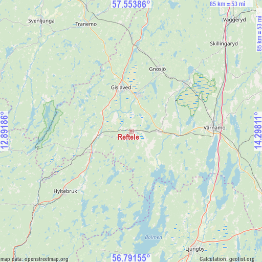
Reftele GPS coordinates[2]
57° 10' 28.812" North, 13° 35' 41.928" East
| Map corner | latitude | longitude |
|---|---|---|
| Upper-left | 57.55386°, | 12.89186° |
| Center: | 57.17467°, | 13.59498° |
| Lower-right: | 56.79155°, | 14.29811° |
| Map W x H: | 84.8×84.8 km | = 52.7×52.7mi |
| max Lat: | 67.85572° ⇑75.8% North |
| Reftele: | 57.17467° |
| min Lat: | ⇓24.2% South 55.34337° |
| min Long | Reftele | max Long |
| 11.1712° | 13.59498° | 24.13676° |
| W 30.4%⇐ | ⇒69.6% E |
Elevation
Elevation of Reftele is 151 m = 495 ft, and this is 68.4 m = 224 ft above average elevation for this country.
| Max E: |
663 m = 2175 ft | 18.3% |
| Reftele | 151 m 495 ft | |
| Avg. | 82.6 m = 271 ft | |
Min E: |
-1 m = -3 ft | 81.7% |
See also: Sweden elevation on elevation.city.
Geographical zone
Reftele is located in North temperate zone (between Tropic of Cancer and the Arctic Circle). Distance of this North polar circle is 1043.9 km =648.6 mi to North.| Distance of | km | miles | from Reftele |
|---|---|---|---|
| North Pole | 3649.8 | 2267.9 | to North |
| Arctic Circle | 1043.9 | 648.6 | to North |
| Tropic Cancer | 3751.3 | 2330.9 | to South |
| Equator | 6357.2 | 3950.2 | to South |


Nearby cities:
15 places around Reftele: (largest is in red/bold)
• Anderstorp
12.3 km =7.6 mi,  10°
10°
• Bor
35.1 km =21.8 mi,  100°
100°
• Bredaryd
8.6 km =5.3 mi,  90°
90°
• Burseryd
19 km =11.8 mi,  278°
278°
• Forsheda
14.2 km =8.8 mi, 94°
• Gislaved
14.8 km =9.2 mi,  347°
347°
• Gnosjö
22.1 km =13.7 mi,  22°
22°
• Grimsås
34.5 km =21.4 mi,  355°
355°
• Hestra
29.8 km =18.5 mi,  0°
0°
• Hillerstorp
23.2 km =14.4 mi,  48°
48°
• Hyltebruk
29 km =18 mi,  227°
227°
• Marieholm
27.8 km =17.3 mi,  33°
33°
• Smålandsstenar
11.1 km =6.9 mi,  262°
262°
• Unnaryd
25.4 km =15.8 mi,  190°
190°
• Värnamo
26.8 km =16.7 mi, 87°
Sources, notices
• [Note1] Compared only with cities in Sweden existing in our database
• [Src1] Map data: © OpenStreetMap contributors (CC-BY-SA)
• [Src2] Other city data from geonames.org with taken over terms of usage.
• [Src3] Geographical zone / Annual Mean Temperature by Robert A. Rohde @ Wikipedia
