Gemla geodata
Gemla (Kronoberg) is a populated place; located in Sweden in Europe/Stockholm (GMT+2) time zone. With population of 1,462 people, there are 669 cities with bigger population in this country. Compared to other cities in Sweden, 79.1% of cities are located further ↑North; 54.9% of cities are located further →East and 82.4% of cities have lower elevation than Gemla. Note1
Administrative division(s):
- Level 1: Kronoberg
- Level 2: Växjö Kommun
- Level 3: Öja
- Level 4: Öja socken


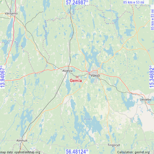
Gemla GPS coordinates[2]
56° 52' 3.108" North, 14° 38' 37.644" East
| Map corner | latitude | longitude |
|---|---|---|
| Upper-left | 57.24987°, | 13.94067° |
| Center: | 56.86753°, | 14.64379° |
| Lower-right: | 56.48124°, | 15.34692° |
| Map W x H: | 85.5×85.5 km | = 53.1×53.1mi |
| max Lat: | 67.85572° ⇑79.1% North |
| Gemla: | 56.86753° |
| min Lat: | ⇓20.9% South 55.34337° |
| min Long | Gemla | max Long |
| 11.1712° | 14.64379° | 24.13676° |
| W 45.1%⇐ | ⇒54.9% E |
Elevation
Elevation of Gemla is 156 m = 512 ft, and this is 73.4 m = 241 ft above average elevation for this country.
| Max E: |
663 m = 2175 ft | 17.6% |
| Gemla | 156 m 512 ft | |
| Avg. | 82.6 m = 271 ft | |
Min E: |
-1 m = -3 ft | 82.4% |
See also: Sweden elevation on elevation.city.
Geographical zone
Gemla is located in North temperate zone (between Tropic of Cancer and the Arctic Circle). Distance of this North polar circle is 1078.1 km =669.9 mi to North.| Distance of | km | miles | from Gemla |
|---|---|---|---|
| North Pole | 3684 | 2289.1 | to North |
| Arctic Circle | 1078.1 | 669.9 | to North |
| Tropic Cancer | 3717.2 | 2309.8 | to South |
| Equator | 6323.1 | 3929 | to South |


Nearby cities:
15 places around Gemla: (largest is in red/bold)
• Alvesta
6.4 km =4 mi,  303°
303°
• Braås
33.1 km =20.6 mi,  48°
48°
• Grimslöv
16.4 km =10.2 mi,  204°
204°
• Hovmantorp
31.5 km =19.6 mi,  106°
106°
• Ingelstad
21.1 km =13.1 mi,  128°
128°
• Lammhult
33.5 km =20.8 mi,  353°
353°
• Liatorp
32 km =19.9 mi,  225°
225°
• Moheda
15.5 km =9.6 mi,  342°
342°
• Rottne
22.7 km =14.1 mi,  43°
43°
• Rydaholm
24.1 km =15 mi, 302°
• Ryssby
29 km =18 mi,  269°
269°
• Vislanda
15.1 km =9.4 mi, 231°
• Väckelsång
30.9 km =19.2 mi,  147°
147°
• Växjö
10.1 km =6.3 mi,  83°
83°
• Åryd
20.9 km =13 mi,  102°
102°
Sources, notices
• [Note1] Compared only with cities in Sweden existing in our database
• [Src1] Map data: © OpenStreetMap contributors (CC-BY-SA)
• [Src2] Other city data from geonames.org with taken over terms of usage.
• [Src3] Geographical zone / Annual Mean Temperature by Robert A. Rohde @ Wikipedia
