Hovmantorp geodata
Hovmantorp (Kronoberg) is a populated place; located in Sweden in Europe/Stockholm (GMT+2) time zone. With population of 3,082 people, there are 400 cities with bigger population in this country. Compared to other cities in Sweden, 80% of cities are located further ↑North; 51.6% of cities are located further ←West and 81.8% of cities have lower elevation than Hovmantorp. Note1
Administrative division(s):
- Level 1: Kronoberg
- Level 2: Lessebo Kommun
- Level 3: Hovmantorp
- Level 4: Hovmantorp socken


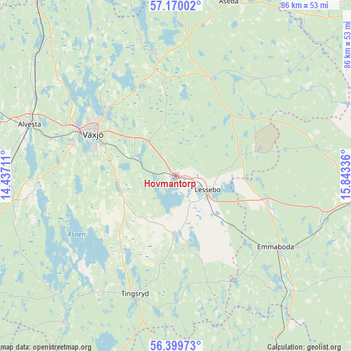
Hovmantorp GPS coordinates[2]
56° 47' 12.66" North, 15° 8' 24.828" East
| Map corner | latitude | longitude |
|---|---|---|
| Upper-left | 57.17002°, | 14.43711° |
| Center: | 56.78685°, | 15.14023° |
| Lower-right: | 56.39973°, | 15.84336° |
| Map W x H: | 85.6×85.6 km | = 53.2×53.2mi |
| max Lat: | 67.85572° ⇑80% North |
| Hovmantorp: | 56.78685° |
| min Lat: | ⇓20% South 55.34337° |
| min Long | Hovmantorp | max Long |
| 11.1712° | 15.14023° | 24.13676° |
| W 51.6%⇐ | ⇒48.4% E |
Elevation
Elevation of Hovmantorp is 152 m = 499 ft, and this is 69.4 m = 228 ft above average elevation for this country.
| Max E: |
663 m = 2175 ft | 18.2% |
| Hovmantorp | 152 m 499 ft | |
| Avg. | 82.6 m = 271 ft | |
Min E: |
-1 m = -3 ft | 81.8% |
See also: Sweden elevation on elevation.city.
Geographical zone
Hovmantorp is located in North temperate zone (between Tropic of Cancer and the Arctic Circle). Distance of this North polar circle is 1087.1 km =675.5 mi to North.| Distance of | km | miles | from Hovmantorp |
|---|---|---|---|
| North Pole | 3693 | 2294.7 | to North |
| Arctic Circle | 1087.1 | 675.5 | to North |
| Tropic Cancer | 3708.2 | 2304.2 | to South |
| Equator | 6314.1 | 3923.4 | to South |


Nearby cities:
15 places around Hovmantorp: (largest is in red/bold)
• Braås
31.6 km =19.6 mi,  350°
350°
• Emmaboda
29.6 km =18.4 mi,  125°
125°
• Gemla
31.5 km =19.6 mi,  286°
286°
• Ingelstad
14.2 km =8.8 mi,  253°
253°
• Kosta
16.8 km =10.4 mi,  68°
68°
• Lenhovda
25.2 km =15.7 mi,  20°
20°
• Lessebo
8.8 km =5.5 mi,  116°
116°
• Orrefors
37.3 km =23.2 mi,  80°
80°
• Rottne
29.4 km =18.3 mi,  330°
330°
• Skruv
18.4 km =11.4 mi, 131°
• Tingsryd
30.8 km =19.1 mi,  198°
198°
• Urshult
35.6 km =22.1 mi,  217°
217°
• Väckelsång
21.9 km =13.6 mi, 218°
• Växjö
22.5 km =14 mi,  296°
296°
• Åryd
10.8 km =6.7 mi, 294°
Sources, notices
• [Note1] Compared only with cities in Sweden existing in our database
• [Src1] Map data: © OpenStreetMap contributors (CC-BY-SA)
• [Src2] Other city data from geonames.org with taken over terms of usage.
• [Src3] Geographical zone / Annual Mean Temperature by Robert A. Rohde @ Wikipedia
