Växjö geodata
Växjö (Kronoberg) is a seat of a first-order administrative division; located in Sweden in Europe/Stockholm (GMT+2) time zone. With population of 65,383 people, there are 23 cities with bigger population in this country. Compared to other cities in Sweden, 79.1% of cities are located further ↑North; 53.2% of cities are located further →East and 85.2% of cities have lower elevation than Växjö. Note1


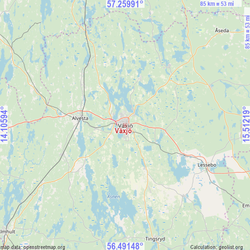
Växjö GPS coordinates[2]
56° 52' 39.612" North, 14° 48' 32.616" East
| Map corner | latitude | longitude |
|---|---|---|
| Upper-left | 57.25991°, | 14.10594° |
| Center: | 56.87767°, | 14.80906° |
| Lower-right: | 56.49148°, | 15.51219° |
| Map W x H: | 85.4×85.4 km | = 53.1×53.1mi |
| max Lat: | 67.85572° ⇑79.1% North |
| Växjö: | 56.87767° |
| min Lat: | ⇓20.9% South 55.34337° |
| min Long | Växjö | max Long |
| 11.1712° | 14.80906° | 24.13676° |
| W 46.8%⇐ | ⇒53.2% E |
Elevation
Elevation of Växjö is 169 m = 554 ft, and this is 86.4 m = 283 ft above average elevation for this country.
| Max E: |
663 m = 2175 ft | 14.8% |
| Växjö | 169 m 554 ft | |
| Avg. | 82.6 m = 271 ft | |
Min E: |
-1 m = -3 ft | 85.2% |
See also: Växjö elevation on elevation.city.
Geographical zone
Växjö is located in North temperate zone (between Tropic of Cancer and the Arctic Circle). Distance of this North polar circle is 1077 km =669.2 mi to North.| Distance of | km | miles | from Växjö |
|---|---|---|---|
| North Pole | 3682.9 | 2288.4 | to North |
| Arctic Circle | 1077 | 669.2 | to North |
| Tropic Cancer | 3718.3 | 2310.4 | to South |
| Equator | 6324.2 | 3929.7 | to South |


Nearby cities:
15 places around Växjö: (largest is in red/bold)
• Alvesta
15.6 km =9.7 mi,  278°
278°
• Braås
25.6 km =15.9 mi,  34°
34°
• Gemla
10.1 km =6.3 mi,  263°
263°
• Grimslöv
23.2 km =14.4 mi,  226°
226°
• Hovmantorp
22.5 km =14 mi,  116°
116°
• Ingelstad
15.6 km =9.7 mi,  155°
155°
• Lammhult
34.9 km =21.7 mi,  336°
336°
• Lenhovda
31.8 km =19.8 mi,  64°
64°
• Lessebo
31.3 km =19.4 mi, 116°
• Moheda
20 km =12.4 mi,  312°
312°
• Rottne
16.4 km =10.2 mi,  19°
19°
• Rydaholm
32.6 km =20.3 mi,  291°
291°
• Vislanda
24.2 km =15 mi,  244°
244°
• Väckelsång
27.9 km =17.3 mi,  166°
166°
• Åryd
11.8 km =7.3 mi, 118°
Sources, notices
• [Note1] Compared only with cities in Sweden existing in our database
• [Src1] Map data: © OpenStreetMap contributors (CC-BY-SA)
• [Src2] Other city data from geonames.org with taken over terms of usage.
• [Src3] Geographical zone / Annual Mean Temperature by Robert A. Rohde @ Wikipedia
