Lammhult geodata
Lammhult (Kronoberg) is a populated place; located in Sweden in Europe/Stockholm (GMT+2) time zone. With population of 1,694 people, there are 598 cities with bigger population in this country. Compared to other cities in Sweden, 76.3% of cities are located further ↑North; 55.8% of cities are located further →East and 90.7% of cities have lower elevation than Lammhult. Note1


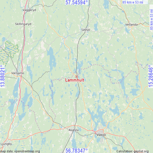
Lammhult GPS coordinates[2]
57° 10' 0.012" North, 14° 34' 59.988" East
| Map corner | latitude | longitude |
|---|---|---|
| Upper-left | 57.54594°, | 13.88021° |
| Center: | 57.16667°, | 14.58333° |
| Lower-right: | 56.78347°, | 15.28646° |
| Map W x H: | 84.8×84.8 km | = 52.7×52.7mi |
| max Lat: | 67.85572° ⇑76.3% North |
| Lammhult: | 57.16667° |
| min Lat: | ⇓23.7% South 55.34337° |
| min Long | Lammhult | max Long |
| 11.1712° | 14.58333° | 24.13676° |
| W 44.2%⇐ | ⇒55.8% E |
Elevation
Elevation of Lammhult is 210 m = 689 ft, and this is 127.4 m = 418 ft above average elevation for this country.
| Max E: |
663 m = 2175 ft | 9.3% |
| Lammhult | 210 m 689 ft | |
| Avg. | 82.6 m = 271 ft | |
Min E: |
-1 m = -3 ft | 90.7% |
See also: Sweden elevation on elevation.city.
Geographical zone
Lammhult is located in North temperate zone (between Tropic of Cancer and the Arctic Circle). Distance of this North polar circle is 1044.8 km =649.2 mi to North.| Distance of | km | miles | from Lammhult |
|---|---|---|---|
| North Pole | 3650.7 | 2268.4 | to North |
| Arctic Circle | 1044.8 | 649.2 | to North |
| Tropic Cancer | 3750.4 | 2330.4 | to South |
| Equator | 6356.3 | 3949.6 | to South |


Nearby cities:
15 places around Lammhult: (largest is in red/bold)
• Alvesta
29.8 km =18.5 mi,  183°
183°
• Bor
25.7 km =16 mi,  257°
257°
• Braås
30.3 km =18.8 mi,  111°
111°
• Burseryd
25.3 km =15.7 mi,  28°
28°
• Gemla
33.5 km =20.8 mi,  173°
173°
• Landsbro
29.3 km =18.2 mi,  40°
40°
• Moheda
18.6 km =11.6 mi, 183°
• Myresjö
33.3 km =20.7 mi, 43°
• Rottne
25.4 km =15.8 mi,  131°
131°
• Rydaholm
26.2 km =16.3 mi,  219°
219°
• Rörvik
8 km =5 mi,  357°
357°
• Stockaryd
16.8 km =10.4 mi,  2°
2°
• Sävsjö
26.7 km =16.6 mi,  10°
10°
• Vrigstad
21.6 km =13.4 mi,  341°
341°
• Värnamo
32.8 km =20.4 mi,  273°
273°
Sources, notices
• [Note1] Compared only with cities in Sweden existing in our database
• [Src1] Map data: © OpenStreetMap contributors (CC-BY-SA)
• [Src2] Other city data from geonames.org with taken over terms of usage.
• [Src3] Geographical zone / Annual Mean Temperature by Robert A. Rohde @ Wikipedia
