Rottne geodata
Rottne (Kronoberg) is a populated place; located in Sweden in Europe/Stockholm (GMT+2) time zone. With population of 2,395 people, there are 465 cities with bigger population in this country. Compared to other cities in Sweden, 77.5% of cities are located further ↑North; 52.5% of cities are located further →East and 88.9% of cities have lower elevation than Rottne. Note1


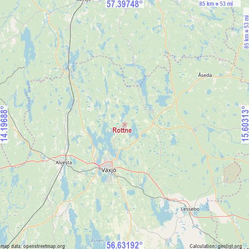
Rottne GPS coordinates[2]
57° 1' 0.012" North, 14° 54' 0" East
| Map corner | latitude | longitude |
|---|---|---|
| Upper-left | 57.39748°, | 14.19688° |
| Center: | 57.01667°, | 14.9° |
| Lower-right: | 56.63192°, | 15.60313° |
| Map W x H: | 85.1×85.1 km | = 52.9×52.9mi |
| max Lat: | 67.85572° ⇑77.5% North |
| Rottne: | 57.01667° |
| min Lat: | ⇓22.5% South 55.34337° |
| min Long | Rottne | max Long |
| 11.1712° | 14.9° | 24.13676° |
| W 47.5%⇐ | ⇒52.5% E |
Elevation
Elevation of Rottne is 190 m = 623 ft, and this is 107.4 m = 352 ft above average elevation for this country.
| Max E: |
663 m = 2175 ft | 11.1% |
| Rottne | 190 m 623 ft | |
| Avg. | 82.6 m = 271 ft | |
Min E: |
-1 m = -3 ft | 88.9% |
See also: Sweden elevation on elevation.city.
Geographical zone
Rottne is located in North temperate zone (between Tropic of Cancer and the Arctic Circle). Distance of this North polar circle is 1061.5 km =659.6 mi to North.| Distance of | km | miles | from Rottne |
|---|---|---|---|
| North Pole | 3667.4 | 2278.8 | to North |
| Arctic Circle | 1061.5 | 659.6 | to North |
| Tropic Cancer | 3733.7 | 2320 | to South |
| Equator | 6339.7 | 3939.3 | to South |


Nearby cities:
15 places around Rottne: (largest is in red/bold)
• Alvesta
24.6 km =15.3 mi,  238°
238°
• Braås
10.6 km =6.6 mi,  58°
58°
• Gemla
22.7 km =14.1 mi,  223°
223°
• Hovmantorp
29.4 km =18.3 mi,  150°
150°
• Ingelstad
29.7 km =18.5 mi,  178°
178°
• Korsberga
34.6 km =21.5 mi,  23°
23°
• Kosta
35.7 km =22.2 mi,  122°
122°
• Lammhult
25.4 km =15.8 mi,  311°
311°
• Lenhovda
23.3 km =14.5 mi,  94°
94°
• Moheda
20.3 km =12.6 mi,  264°
264°
• Rörvik
31.4 km =19.5 mi,  321°
321°
• Skruv
21.9 km =13.6 mi,  47°
47°
• Växjö
16.4 km =10.2 mi,  199°
199°
• Åryd
21.6 km =13.4 mi,  167°
167°
• Åseda
31.8 km =19.8 mi, 57°
Sources, notices
• [Note1] Compared only with cities in Sweden existing in our database
• [Src1] Map data: © OpenStreetMap contributors (CC-BY-SA)
• [Src2] Other city data from geonames.org with taken over terms of usage.
• [Src3] Geographical zone / Annual Mean Temperature by Robert A. Rohde @ Wikipedia
