Furulund geodata
Furulund (Skåne) is a populated place; located in Sweden in Europe/Stockholm (GMT+2) time zone. With population of 4,359 people, there are 310 cities with bigger population in this country. Compared to other cities in Sweden, 95.2% of cities are located further ↑North; 77.6% of cities are located further →East and 78.5% of cities have higher elevation than Furulund. Note1


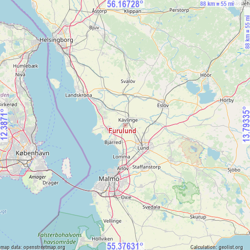
Furulund GPS coordinates[2]
55° 46' 25.68" North, 13° 5' 24.792" East
| Map corner | latitude | longitude |
|---|---|---|
| Upper-left | 56.16728°, | 12.3871° |
| Center: | 55.7738°, | 13.09022° |
| Lower-right: | 55.37631°, | 13.79335° |
| Map W x H: | 87.9×87.9 km | = 54.6×54.6mi |
| max Lat: | 67.85572° ⇑95.2% North |
| Furulund: | 55.7738° |
| min Lat: | ⇓4.8% South 55.34337° |
| min Long | Furulund | max Long |
| 11.1712° | 13.09022° | 24.13676° |
| W 22.4%⇐ | ⇒77.6% E |
Elevation
Elevation of Furulund is 17 m = 56 ft, and this is 65.6 m = 215 ft below average elevation for this country.
| Max E: |
663 m = 2175 ft | 78.5% |
| Avg. | 82.6 m = 271 ft | |
| Furulund | 17 m = 56 ft | |
Min E: |
-1 m = -3 ft | 21.5% |
See also: Sweden elevation on elevation.city.
Geographical zone
Furulund is located in North temperate zone (between Tropic of Cancer and the Arctic Circle). Distance of this North polar circle is 1199.7 km =745.5 mi to North.| Distance of | km | miles | from Furulund |
|---|---|---|---|
| North Pole | 3805.6 | 2364.7 | to North |
| Arctic Circle | 1199.7 | 745.5 | to North |
| Tropic Cancer | 3595.5 | 2234.1 | to South |
| Equator | 6201.5 | 3853.4 | to South |


Nearby cities:
15 places around Furulund: (largest is in red/bold)
• Barsebäck
8.8 km =5.5 mi,  264°
264°
• Bjärred
7.8 km =4.8 mi,  215°
215°
• Dösjebro
6.5 km =4 mi,  323°
323°
• Hjärup
12.1 km =7.5 mi,  165°
165°
• Hofterup
7.7 km =4.8 mi,  296°
296°
• Kävlinge
2.4 km =1.5 mi,  31°
31°
• Lomma
11.4 km =7.1 mi,  186°
186°
• Lund
9.9 km =6.2 mi,  139°
139°
• Löddeköpinge
4.7 km =2.9 mi, 260°
• Marieholm
11 km =6.8 mi,  19°
19°
• Sandskogen
6.9 km =4.3 mi, 255°
• Saxtorpsskogen
11.2 km =7 mi,  305°
305°
• Stångby
7.2 km =4.5 mi,  111°
111°
• Teckomatorp
10.3 km =6.4 mi,  357°
357°
• Åkarp
13.4 km =8.3 mi, 174°
Sources, notices
• [Note1] Compared only with cities in Sweden existing in our database
• [Src1] Map data: © OpenStreetMap contributors (CC-BY-SA)
• [Src2] Other city data from geonames.org with taken over terms of usage.
• [Src3] Geographical zone / Annual Mean Temperature by Robert A. Rohde @ Wikipedia
