Marieholm geodata
Marieholm (Skåne) is a populated place; located in Sweden in Europe/Stockholm (GMT+2) time zone. With population of 1,604 people, there are 621 cities with bigger population in this country. Compared to other cities in Sweden, 94.4% of cities are located further ↑North; 76.1% of cities are located further →East and 62.2% of cities have higher elevation than Marieholm. Note1


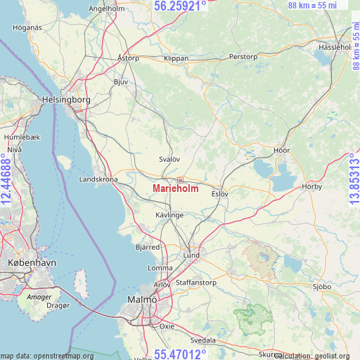
Marieholm GPS coordinates[2]
55° 52' 0.012" North, 13° 9' 0" East
| Map corner | latitude | longitude |
|---|---|---|
| Upper-left | 56.25921°, | 12.44688° |
| Center: | 55.86667°, | 13.15° |
| Lower-right: | 55.47012°, | 13.85313° |
| Map W x H: | 87.7×87.7 km | = 54.5×54.5mi |
| max Lat: | 67.85572° ⇑94.4% North |
| Marieholm: | 55.86667° |
| min Lat: | ⇓5.6% South 55.34337° |
| min Long | Marieholm | max Long |
| 11.1712° | 13.15° | 24.13676° |
| W 23.9%⇐ | ⇒76.1% E |
Elevation
Elevation of Marieholm is 33 m = 108 ft, and this is 49.6 m = 163 ft below average elevation for this country.
| Max E: |
663 m = 2175 ft | 62.2% |
| Avg. | 82.6 m = 271 ft | |
| Marieholm | 33 m = 108 ft | |
Min E: |
-1 m = -3 ft | 37.8% |
See also: Sweden elevation on elevation.city.
Geographical zone
Marieholm is located in North temperate zone (between Tropic of Cancer and the Arctic Circle). Distance of this North polar circle is 1189.4 km =739.1 mi to North.| Distance of | km | miles | from Marieholm |
|---|---|---|---|
| North Pole | 3795.3 | 2358.3 | to North |
| Arctic Circle | 1189.4 | 739.1 | to North |
| Tropic Cancer | 3605.9 | 2240.6 | to South |
| Equator | 6211.8 | 3859.8 | to South |


Nearby cities:
15 places around Marieholm: (largest is in red/bold)
• Asmundtorp
13.6 km =8.5 mi,  277°
277°
• Billeberga
9.5 km =5.9 mi, 281°
• Dösjebro
9.1 km =5.7 mi,  236°
236°
• Eslöv
10.1 km =6.3 mi,  107°
107°
• Furulund
11 km =6.8 mi,  199°
199°
• Hofterup
12.7 km =7.9 mi, 237°
• Häljarp
14.7 km =9.1 mi,  262°
262°
• Kävlinge
8.7 km =5.4 mi, 196°
• Kågeröd
15.3 km =9.5 mi,  345°
345°
• Löddeköpinge
13.9 km =8.6 mi,  216°
216°
• Saxtorpsskogen
13.4 km =8.3 mi,  253°
253°
• Stehag
15.8 km =9.8 mi,  75°
75°
• Stångby
13.3 km =8.3 mi,  166°
166°
• Svalöv
5.8 km =3.6 mi,  333°
333°
• Teckomatorp
4.2 km =2.6 mi,  270°
270°
Sources, notices
• [Note1] Compared only with cities in Sweden existing in our database
• [Src1] Map data: © OpenStreetMap contributors (CC-BY-SA)
• [Src2] Other city data from geonames.org with taken over terms of usage.
• [Src3] Geographical zone / Annual Mean Temperature by Robert A. Rohde @ Wikipedia
