Hofterup geodata
Hofterup (Skåne) is a populated place; located in Sweden in Europe/Stockholm (GMT+2) time zone. With population of 3,814 people, there are 339 cities with bigger population in this country. Compared to other cities in Sweden, 95% of cities are located further ↑North; 80.4% of cities are located further →East and 85.7% of cities have higher elevation than Hofterup. Note1


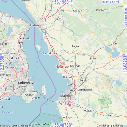
Hofterup GPS coordinates[2]
55° 48' 17.46" North, 12° 58' 46.92" East
| Map corner | latitude | longitude |
|---|---|---|
| Upper-left | 56.19801°, | 12.27658° |
| Center: | 55.80485°, | 12.9797° |
| Lower-right: | 55.40768°, | 13.68283° |
| Map W x H: | 87.9×87.9 km | = 54.6×54.6mi |
| max Lat: | 67.85572° ⇑95% North |
| Hofterup: | 55.80485° |
| min Lat: | ⇓5% South 55.34337° |
| min Long | Hofterup | max Long |
| 11.1712° | 12.9797° | 24.13676° |
| W 19.6%⇐ | ⇒80.4% E |
Elevation
Elevation of Hofterup is 12 m = 39 ft, and this is 70.6 m = 232 ft below average elevation for this country.
| Max E: |
663 m = 2175 ft | 85.7% |
| Avg. | 82.6 m = 271 ft | |
| Hofterup | 12 m = 39 ft | |
Min E: |
-1 m = -3 ft | 14.3% |
See also: Sweden elevation on elevation.city.
Geographical zone
Hofterup is located in North temperate zone (between Tropic of Cancer and the Arctic Circle). Distance of this North polar circle is 1196.3 km =743.3 mi to North.| Distance of | km | miles | from Hofterup |
|---|---|---|---|
| North Pole | 3802.1 | 2362.5 | to North |
| Arctic Circle | 1196.3 | 743.3 | to North |
| Tropic Cancer | 3599 | 2236.3 | to South |
| Equator | 6204.9 | 3855.5 | to South |


Nearby cities:
15 places around Hofterup: (largest is in red/bold)
• Asmundtorp
9.2 km =5.7 mi,  341°
341°
• Barsebäck
4.6 km =2.9 mi,  203°
203°
• Billeberga
8.8 km =5.5 mi,  8°
8°
• Bjärred
10.1 km =6.3 mi,  166°
166°
• Dösjebro
3.6 km =2.2 mi,  59°
59°
• Furulund
7.7 km =4.8 mi,  116°
116°
• Häljarp
6.4 km =4 mi,  321°
321°
• Kävlinge
8.3 km =5.2 mi,  100°
100°
• Landskrona
11.9 km =7.4 mi,  308°
308°
• Löddeköpinge
4.8 km =3 mi,  151°
151°
• Marieholm
12.7 km =7.9 mi, 57°
• Sandskogen
5.2 km =3.2 mi,  177°
177°
• Saxtorpsskogen
3.7 km =2.3 mi, 323°
• Svalöv
14.5 km =9 mi,  33°
33°
• Teckomatorp
9.4 km =5.8 mi,  43°
43°
Sources, notices
• [Note1] Compared only with cities in Sweden existing in our database
• [Src1] Map data: © OpenStreetMap contributors (CC-BY-SA)
• [Src2] Other city data from geonames.org with taken over terms of usage.
• [Src3] Geographical zone / Annual Mean Temperature by Robert A. Rohde @ Wikipedia
