Saxtorpsskogen geodata
Saxtorpsskogen (Skåne) is a populated place; located in Sweden in Europe/Stockholm (GMT+2) time zone. With population of 1,174 people, there are 753 cities with bigger population in this country. Compared to other cities in Sweden, 94.8% of cities are located further ↑North; 81.5% of cities are located further →East and 75.3% of cities have higher elevation than Saxtorpsskogen. Note1


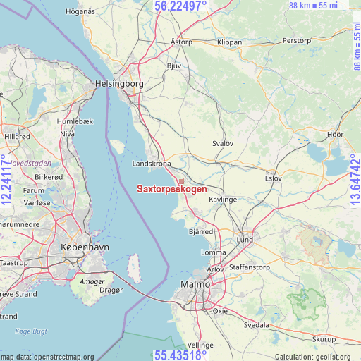
Saxtorpsskogen GPS coordinates[2]
55° 49' 55.488" North, 12° 56' 39.444" East
| Map corner | latitude | longitude |
|---|---|---|
| Upper-left | 56.22497°, | 12.24117° |
| Center: | 55.83208°, | 12.94429° |
| Lower-right: | 55.43518°, | 13.64742° |
| Map W x H: | 87.8×87.8 km | = 54.6×54.6mi |
| max Lat: | 67.85572° ⇑94.8% North |
| Saxtorpsskogen: | 55.83208° |
| min Lat: | ⇓5.2% South 55.34337° |
| min Long | Saxtorpsskogen | max Long |
| 11.1712° | 12.94429° | 24.13676° |
| W 18.5%⇐ | ⇒81.5% E |
Elevation
Elevation of Saxtorpsskogen is 20 m = 66 ft, and this is 62.6 m = 205 ft below average elevation for this country.
| Max E: |
663 m = 2175 ft | 75.3% |
| Avg. | 82.6 m = 271 ft | |
| Saxtorpsskogen | 20 m = 66 ft | |
Min E: |
-1 m = -3 ft | 24.7% |
See also: Sweden elevation on elevation.city.
Geographical zone
Saxtorpsskogen is located in North temperate zone (between Tropic of Cancer and the Arctic Circle). Distance of this North polar circle is 1193.2 km =741.4 mi to North.| Distance of | km | miles | from Saxtorpsskogen |
|---|---|---|---|
| North Pole | 3799.1 | 2360.7 | to North |
| Arctic Circle | 1193.2 | 741.4 | to North |
| Tropic Cancer | 3602 | 2238.2 | to South |
| Equator | 6207.9 | 3857.4 | to South |


Nearby cities:
15 places around Saxtorpsskogen: (largest is in red/bold)
• Asmundtorp
5.7 km =3.5 mi,  353°
353°
• Barsebäck
7.3 km =4.5 mi,  177°
177°
• Billeberga
6.7 km =4.2 mi,  31°
31°
• Bjärred
13.6 km =8.5 mi,  160°
160°
• Dösjebro
5.4 km =3.4 mi,  103°
103°
• Furulund
11.2 km =7 mi,  125°
125°
• Hofterup
3.7 km =2.3 mi,  143°
143°
• Häljarp
2.6 km =1.6 mi,  319°
319°
• Kävlinge
11.3 km =7 mi,  113°
113°
• Landskrona
8.3 km =5.2 mi,  301°
301°
• Löddeköpinge
8.6 km =5.3 mi,  148°
148°
• Marieholm
13.4 km =8.3 mi,  73°
73°
• Sandskogen
8.6 km =5.3 mi, 163°
• Svalöv
13.6 km =8.5 mi,  48°
48°
• Teckomatorp
9.5 km =5.9 mi, 66°
Sources, notices
• [Note1] Compared only with cities in Sweden existing in our database
• [Src1] Map data: © OpenStreetMap contributors (CC-BY-SA)
• [Src2] Other city data from geonames.org with taken over terms of usage.
• [Src3] Geographical zone / Annual Mean Temperature by Robert A. Rohde @ Wikipedia
