Dösjebro geodata
Dösjebro (Skåne) is a populated place; located in Sweden in Europe/Stockholm (GMT+2) time zone. With population of 866 people, there are 913 cities with bigger population in this country. Compared to other cities in Sweden, 94.9% of cities are located further ↑North; 79.1% of cities are located further →East and 85.7% of cities have higher elevation than Dösjebro. Note1
Administrative division(s):
- Level 1: Skåne
- Level 2: Kävlinge Kommun
- Level 3: Västra Karaby
- Level 4: Västra Karaby socken


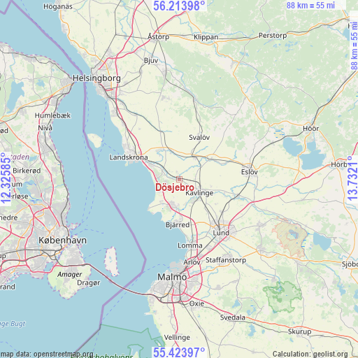
Dösjebro GPS coordinates[2]
55° 49' 15.528" North, 13° 1' 44.292" East
| Map corner | latitude | longitude |
|---|---|---|
| Upper-left | 56.21398°, | 12.32585° |
| Center: | 55.82098°, | 13.02897° |
| Lower-right: | 55.42397°, | 13.7321° |
| Map W x H: | 87.8×87.8 km | = 54.6×54.6mi |
| max Lat: | 67.85572° ⇑94.9% North |
| Dösjebro: | 55.82098° |
| min Lat: | ⇓5.1% South 55.34337° |
| min Long | Dösjebro | max Long |
| 11.1712° | 13.02897° | 24.13676° |
| W 20.9%⇐ | ⇒79.1% E |
Elevation
Elevation of Dösjebro is 12 m = 39 ft, and this is 70.6 m = 232 ft below average elevation for this country.
| Max E: |
663 m = 2175 ft | 85.7% |
| Avg. | 82.6 m = 271 ft | |
| Dösjebro | 12 m = 39 ft | |
Min E: |
-1 m = -3 ft | 14.3% |
See also: Sweden elevation on elevation.city.
Geographical zone
Dösjebro is located in North temperate zone (between Tropic of Cancer and the Arctic Circle). Distance of this North polar circle is 1194.5 km =742.2 mi to North.| Distance of | km | miles | from Dösjebro |
|---|---|---|---|
| North Pole | 3800.4 | 2361.5 | to North |
| Arctic Circle | 1194.5 | 742.2 | to North |
| Tropic Cancer | 3600.8 | 2237.4 | to South |
| Equator | 6206.7 | 3856.7 | to South |


Nearby cities:
15 places around Dösjebro: (largest is in red/bold)
• Asmundtorp
9.1 km =5.7 mi,  319°
319°
• Barsebäck
7.8 km =4.8 mi,  219°
219°
• Billeberga
7.2 km =4.5 mi,  345°
345°
• Bjärred
11.6 km =7.2 mi,  183°
183°
• Furulund
6.5 km =4 mi,  143°
143°
• Hofterup
3.6 km =2.2 mi,  239°
239°
• Häljarp
7.7 km =4.8 mi,  294°
294°
• Kävlinge
6 km =3.7 mi,  122°
122°
• Löddeköpinge
6.1 km =3.8 mi,  187°
187°
• Marieholm
9.1 km =5.7 mi,  56°
56°
• Sandskogen
7.6 km =4.7 mi,  202°
202°
• Saxtorpsskogen
5.4 km =3.4 mi,  283°
283°
• Stångby
13.2 km =8.2 mi,  126°
126°
• Svalöv
11.4 km =7.1 mi,  25°
25°
• Teckomatorp
6.1 km =3.8 mi, 33°
Sources, notices
• [Note1] Compared only with cities in Sweden existing in our database
• [Src1] Map data: © OpenStreetMap contributors (CC-BY-SA)
• [Src2] Other city data from geonames.org with taken over terms of usage.
• [Src3] Geographical zone / Annual Mean Temperature by Robert A. Rohde @ Wikipedia
