Flyinge geodata
Flyinge (Skåne) is a populated place; located in Sweden in Europe/Stockholm (GMT+2) time zone. With population of 992 people, there are 820 cities with bigger population in this country. Compared to other cities in Sweden, 95.5% of cities are located further ↑North; 73.3% of cities are located further →East and 72.8% of cities have higher elevation than Flyinge. Note1


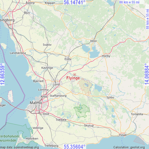
Flyinge GPS coordinates[2]
55° 45' 13.428" North, 13° 22' 0.156" East
| Map corner | latitude | longitude |
|---|---|---|
| Upper-left | 56.14741°, | 12.66359° |
| Center: | 55.75373°, | 13.36671° |
| Lower-right: | 55.35604°, | 14.06984° |
| Map W x H: | 88×88 km | = 54.7×54.7mi |
| max Lat: | 67.85572° ⇑95.5% North |
| Flyinge: | 55.75373° |
| min Lat: | ⇓4.5% South 55.34337° |
| min Long | Flyinge | max Long |
| 11.1712° | 13.36671° | 24.13676° |
| W 26.7%⇐ | ⇒73.3% E |
Elevation
Elevation of Flyinge is 22 m = 72 ft, and this is 60.6 m = 199 ft below average elevation for this country.
| Max E: |
663 m = 2175 ft | 72.8% |
| Avg. | 82.6 m = 271 ft | |
| Flyinge | 22 m = 72 ft | |
Min E: |
-1 m = -3 ft | 27.2% |
See also: Sweden elevation on elevation.city.
Geographical zone
Flyinge is located in North temperate zone (between Tropic of Cancer and the Arctic Circle). Distance of this North polar circle is 1201.9 km =746.8 mi to North.| Distance of | km | miles | from Flyinge |
|---|---|---|---|
| North Pole | 3807.8 | 2366.1 | to North |
| Arctic Circle | 1201.9 | 746.8 | to North |
| Tropic Cancer | 3593.3 | 2232.8 | to South |
| Equator | 6199.2 | 3852 | to South |


Nearby cities:
15 places around Flyinge: (largest is in red/bold)
• Dalby
9.8 km =6.1 mi,  186°
186°
• Eslöv
10.3 km =6.4 mi,  337°
337°
• Furulund
17.4 km =10.8 mi,  277°
277°
• Genarp
17.3 km =10.7 mi,  173°
173°
• Harlösa
10.8 km =6.7 mi,  112°
112°
• Hjärup
17.1 km =10.6 mi,  236°
236°
• Idala
17.1 km =10.6 mi,  150°
150°
• Kävlinge
16.6 km =10.3 mi, 284°
• Lund
12.1 km =7.5 mi, 243°
• Löberöd
10.2 km =6.3 mi,  75°
75°
• Staffanstorp
15.9 km =9.9 mi,  219°
219°
• Stehag
16.6 km =10.3 mi,  6°
6°
• Stångby
10.6 km =6.6 mi,  267°
267°
• Södra Sandby
4.3 km =2.7 mi,  197°
197°
• Veberöd
15.3 km =9.5 mi, 151°
Sources, notices
• [Note1] Compared only with cities in Sweden existing in our database
• [Src1] Map data: © OpenStreetMap contributors (CC-BY-SA)
• [Src2] Other city data from geonames.org with taken over terms of usage.
• [Src3] Geographical zone / Annual Mean Temperature by Robert A. Rohde @ Wikipedia
