Eslöv geodata
Eslöv (Skåne) is a seat of a second-order administrative division; located in Sweden in Europe/Stockholm (GMT+2) time zone. With population of 18,592 people, there are 83 cities with bigger population in this country. Compared to other cities in Sweden, 94.7% of cities are located further ↑North; 74.2% of cities are located further →East and 59.2% of cities have lower elevation than Eslöv. Note1


Eslöv GPS coordinates[2]
55° 50' 21.408" North, 13° 18' 14.148" East
| Map corner | latitude | longitude |
|---|---|---|
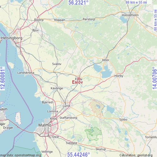
| Upper-left | 56.2321°, | 12.60081° |
| Center: | 55.83928°, | 13.30393° |
| Lower-right: | 55.44246°, | 14.00706° |
| Map W x H: | 87.8×87.8 km | = 54.6×54.6mi |
| max Lat: | 67.85572° ⇑94.7% North |
| Eslöv: | 55.83928° |
| min Lat: | ⇓5.3% South 55.34337° |
| min Long | Eslöv | max Long |
| 11.1712° | 13.30393° | 24.13676° |
| W 25.8%⇐ | ⇒74.2% E |
Elevation
Elevation of Eslöv is 68 m = 223 ft, and this is 14.6 m = 48 ft below average elevation for this country.
| Max E: |
663 m = 2175 ft | 40.8% |
| Avg. | 82.6 m = 271 ft | |
| Eslöv | 68 m = 223 ft | |
Min E: |
-1 m = -3 ft | 59.2% |
See also: Sweden elevation on elevation.city.
Geographical zone
Eslöv is located in North temperate zone (between Tropic of Cancer and the Arctic Circle). Distance of this North polar circle is 1192.4 km =740.9 mi to North.| Distance of | km | miles | from Eslöv |
|---|---|---|---|
| North Pole | 3798.3 | 2360.2 | to North |
| Arctic Circle | 1192.4 | 740.9 | to North |
| Tropic Cancer | 3602.8 | 2238.7 | to South |
| Equator | 6208.7 | 3857.9 | to South |


Nearby cities:
15 places around Eslöv: (largest is in red/bold)
• Dösjebro
17.3 km =10.7 mi,  263°
263°
• Flyinge
10.3 km =6.4 mi,  157°
157°
• Furulund
15.2 km =9.4 mi,  241°
241°
• Höör
18.1 km =11.2 mi,  54°
54°
• Kävlinge
13.2 km =8.2 mi,  246°
246°
• Lund
16.4 km =10.2 mi,  205°
205°
• Löberöd
15.4 km =9.6 mi,  117°
117°
• Marieholm
10.1 km =6.3 mi,  287°
287°
• Röstånga
17.9 km =11.1 mi,  355°
355°
• Stehag
9 km =5.6 mi,  39°
39°
• Stångby
11.9 km =7.4 mi, 213°
• Svalöv
14.8 km =9.2 mi,  303°
303°
• Sätofta
17.6 km =10.9 mi,  60°
60°
• Södra Sandby
13.9 km =8.6 mi,  168°
168°
• Teckomatorp
14.1 km =8.8 mi,  282°
282°
Sources, notices
• [Note1] Compared only with cities in Sweden existing in our database
• [Src1] Map data: © OpenStreetMap contributors (CC-BY-SA)
• [Src2] Other city data from geonames.org with taken over terms of usage.
• [Src3] Geographical zone / Annual Mean Temperature by Robert A. Rohde @ Wikipedia
