Falun geodata
Falun (Dalarna) is a seat of a first-order administrative division; located in Sweden in Europe/Stockholm (GMT+2) time zone. With population of 37,000 people, there are 38 cities with bigger population in this country. Compared to other cities in Sweden, 79.6% of cities are located further ↓South; 57.5% of cities are located further ←West and 69.3% of cities have lower elevation than Falun. Note1


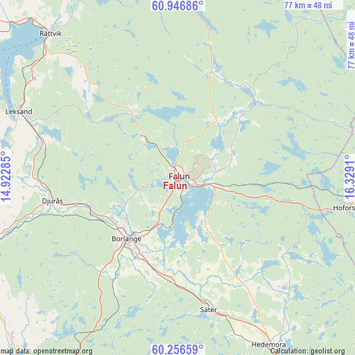
Falun GPS coordinates[2]
60° 36' 12.852" North, 15° 37' 33.492" East
| Map corner | latitude | longitude |
|---|---|---|
| Upper-left | 60.94686°, | 14.92285° |
| Center: | 60.60357°, | 15.62597° |
| Lower-right: | 60.25659°, | 16.3291° |
| Map W x H: | 76.8×76.7 km | = 47.7×47.7mi |
| max Lat: | 67.85572° ⇑20.4% North |
| Falun: | 60.60357° |
| min Lat: | ⇓79.6% South 55.34337° |
| min Long | Falun | max Long |
| 11.1712° | 15.62597° | 24.13676° |
| W 57.5%⇐ | ⇒42.5% E |
Elevation
Elevation of Falun is 97 m = 318 ft, and this is 14.4 m = 47 ft above average elevation for this country.
| Max E: |
663 m = 2175 ft | 30.7% |
| Falun | 97 m 318 ft | |
| Avg. | 82.6 m = 271 ft | |
Min E: |
-1 m = -3 ft | 69.3% |
See also: Sweden elevation on elevation.city.
Geographical zone
Falun is located in North temperate zone (between Tropic of Cancer and the Arctic Circle). Distance of this North polar circle is 662.7 km =411.8 mi to North.| Distance of | km | miles | from Falun |
|---|---|---|---|
| North Pole | 3268.6 | 2031 | to North |
| Arctic Circle | 662.7 | 411.8 | to North |
| Tropic Cancer | 4132.6 | 2567.9 | to South |
| Equator | 6738.5 | 4187.1 | to South |


Nearby cities:
15 places around Falun: (largest is in red/bold)
• Bengtsheden
18.1 km =11.2 mi,  48°
48°
• Bjursås
17.6 km =10.9 mi,  327°
327°
• Borlänge
16.7 km =10.4 mi,  218°
218°
• Enbacka
21.6 km =13.4 mi,  184°
184°
• Grycksbo
12.1 km =7.5 mi,  320°
320°
• Linghed
23.4 km =14.5 mi,  31°
31°
• Mora
22.7 km =14.1 mi, 183°
• Ornäs
11.4 km =7.1 mi,  203°
203°
• Romme
20.1 km =12.5 mi, 200°
• Sundborn
9.2 km =5.7 mi,  56°
56°
• Svärdsjö
21.4 km =13.3 mi,  44°
44°
• Sågmyra
22.5 km =14 mi,  303°
303°
• Tomtebo
21.4 km =13.3 mi,  166°
166°
• Torsång
15.6 km =9.7 mi,  192°
192°
• Vika
11.2 km =7 mi,  153°
153°
Sources, notices
• [Note1] Compared only with cities in Sweden existing in our database
• [Src1] Map data: © OpenStreetMap contributors (CC-BY-SA)
• [Src2] Other city data from geonames.org with taken over terms of usage.
• [Src3] Geographical zone / Annual Mean Temperature by Robert A. Rohde @ Wikipedia
