Svärdsjö geodata
Svärdsjö (Dalarna) is a populated place; located in Sweden in Europe/Stockholm (GMT+2) time zone. With population of 1,335 people, there are 698 cities with bigger population in this country. Compared to other cities in Sweden, 81.4% of cities are located further ↓South; 61% of cities are located further ←West and 77.7% of cities have lower elevation than Svärdsjö. Note1


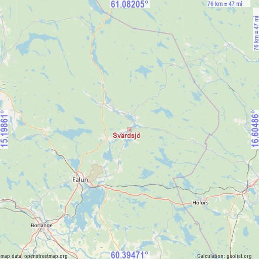
Svärdsjö GPS coordinates[2]
60° 44' 24.792" North, 15° 54' 6.228" East
| Map corner | latitude | longitude |
|---|---|---|
| Upper-left | 61.08205°, | 15.19861° |
| Center: | 60.74022°, | 15.90173° |
| Lower-right: | 60.39471°, | 16.60486° |
| Map W x H: | 76.4×76.4 km | = 47.5×47.5mi |
| max Lat: | 67.85572° ⇑18.6% North |
| Svärdsjö: | 60.74022° |
| min Lat: | ⇓81.4% South 55.34337° |
| min Long | Svärdsjö | max Long |
| 11.1712° | 15.90173° | 24.13676° |
| W 61%⇐ | ⇒39% E |
Elevation
Elevation of Svärdsjö is 132 m = 433 ft, and this is 49.4 m = 162 ft above average elevation for this country.
| Max E: |
663 m = 2175 ft | 22.3% |
| Svärdsjö | 132 m 433 ft | |
| Avg. | 82.6 m = 271 ft | |
Min E: |
-1 m = -3 ft | 77.7% |
See also: Sweden elevation on elevation.city.
Geographical zone
Svärdsjö is located in North temperate zone (between Tropic of Cancer and the Arctic Circle). Distance of this North polar circle is 647.5 km =402.3 mi to North.| Distance of | km | miles | from Svärdsjö |
|---|---|---|---|
| North Pole | 3253.4 | 2021.6 | to North |
| Arctic Circle | 647.5 | 402.3 | to North |
| Tropic Cancer | 4147.8 | 2577.3 | to South |
| Equator | 6753.7 | 4196.6 | to South |


Nearby cities:
15 places around Svärdsjö: (largest is in red/bold)
• Bengtsheden
3.5 km =2.2 mi,  206°
206°
• Bjursås
24.4 km =15.2 mi,  269°
269°
• Enviken
9.2 km =5.7 mi,  315°
315°
• Falun
21.4 km =13.3 mi,  224°
224°
• Grycksbo
23.4 km =14.5 mi,  255°
255°
• Hofors
30.1 km =18.7 mi,  135°
135°
• Linghed
5.6 km =3.5 mi,  329°
329°
• Långshyttan
32.9 km =20.4 mi,  166°
166°
• Ornäs
32.3 km =20.1 mi, 217°
• Sundborn
12.4 km =7.7 mi, 216°
• Sågmyra
33.7 km =20.9 mi, 265°
• Tomtebo
37.4 km =23.2 mi,  195°
195°
• Torsång
35.5 km =22.1 mi, 211°
• Vika
27.2 km =16.9 mi, 201°
• Åshammar
37.6 km =23.4 mi,  107°
107°
Sources, notices
• [Note1] Compared only with cities in Sweden existing in our database
• [Src1] Map data: © OpenStreetMap contributors (CC-BY-SA)
• [Src2] Other city data from geonames.org with taken over terms of usage.
• [Src3] Geographical zone / Annual Mean Temperature by Robert A. Rohde @ Wikipedia
