Sundborn geodata
Sundborn (Dalarna) is a populated place; located in Sweden in Europe/Stockholm (GMT+2) time zone. With population of 923 people, there are 866 cities with bigger population in this country. Compared to other cities in Sweden, 80.1% of cities are located further ↓South; 58.9% of cities are located further ←West and 72.3% of cities have lower elevation than Sundborn. Note1


Sundborn GPS coordinates[2]
60° 39' 0" North, 15° 46' 0.012" East
| Map corner | latitude | longitude |
|---|---|---|
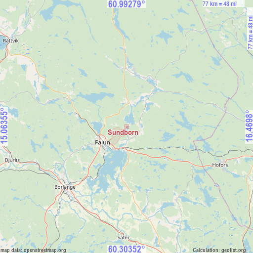
| Upper-left | 60.99279°, | 15.06355° |
| Center: | 60.65°, | 15.76667° |
| Lower-right: | 60.30352°, | 16.4698° |
| Map W x H: | 76.6×76.6 km | = 47.6×47.6mi |
| max Lat: | 67.85572° ⇑19.9% North |
| Sundborn: | 60.65° |
| min Lat: | ⇓80.1% South 55.34337° |
| min Long | Sundborn | max Long |
| 11.1712° | 15.76667° | 24.13676° |
| W 58.9%⇐ | ⇒41.1% E |
Elevation
Elevation of Sundborn is 107 m = 351 ft, and this is 24.4 m = 80 ft above average elevation for this country.
| Max E: |
663 m = 2175 ft | 27.7% |
| Sundborn | 107 m 351 ft | |
| Avg. | 82.6 m = 271 ft | |
Min E: |
-1 m = -3 ft | 72.3% |
See also: Sweden elevation on elevation.city.
Geographical zone
Sundborn is located in North temperate zone (between Tropic of Cancer and the Arctic Circle). Distance of this North polar circle is 657.5 km =408.6 mi to North.| Distance of | km | miles | from Sundborn |
|---|---|---|---|
| North Pole | 3263.4 | 2027.8 | to North |
| Arctic Circle | 657.5 | 408.6 | to North |
| Tropic Cancer | 4137.7 | 2571 | to South |
| Equator | 6743.6 | 4190.3 | to South |


Nearby cities:
15 places around Sundborn: (largest is in red/bold)
• Bengtsheden
9 km =5.6 mi,  40°
40°
• Bjursås
19.6 km =12.2 mi,  299°
299°
• Borlänge
25.6 km =15.9 mi,  224°
224°
• Enviken
16.7 km =10.4 mi,  3°
3°
• Falun
9.2 km =5.7 mi,  236°
236°
• Grycksbo
15.9 km =9.9 mi,  285°
285°
• Linghed
15.5 km =9.6 mi,  16°
16°
• Långshyttan
26.5 km =16.5 mi,  145°
145°
• Ornäs
19.9 km =12.4 mi, 218°
• Romme
28.2 km =17.5 mi,  211°
211°
• Svärdsjö
12.4 km =7.7 mi, 36°
• Sågmyra
27.3 km =17 mi, 285°
• Tomtebo
26.1 km =16.2 mi,  186°
186°
• Torsång
23.1 km =14.4 mi, 208°
• Vika
15.4 km =9.6 mi, 190°
Sources, notices
• [Note1] Compared only with cities in Sweden existing in our database
• [Src1] Map data: © OpenStreetMap contributors (CC-BY-SA)
• [Src2] Other city data from geonames.org with taken over terms of usage.
• [Src3] Geographical zone / Annual Mean Temperature by Robert A. Rohde @ Wikipedia
