Sandhem geodata
Sandhem (Jönköping) is a populated place; located in Sweden in Europe/Stockholm (GMT+2) time zone. With population of 673 people, there are 1094 cities with bigger population in this country. Compared to other cities in Sweden, 61.1% of cities are located further ↑North; 66.8% of cities are located further →East and 93.8% of cities have lower elevation than Sandhem. Note1


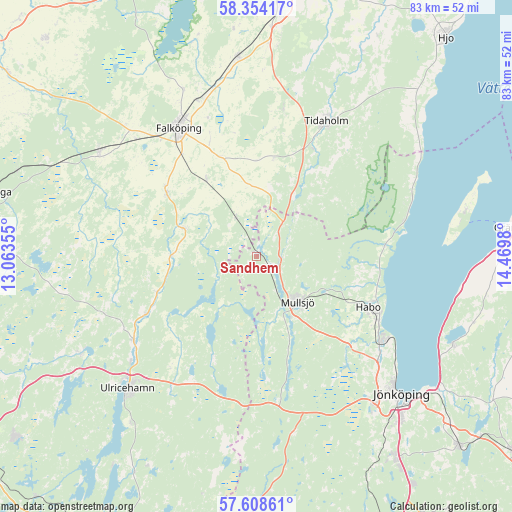
Sandhem GPS coordinates[2]
57° 58' 59.988" North, 13° 46' 0.012" East
| Map corner | latitude | longitude |
|---|---|---|
| Upper-left | 58.35417°, | 13.06355° |
| Center: | 57.98333°, | 13.76667° |
| Lower-right: | 57.60861°, | 14.4698° |
| Map W x H: | 82.9×82.9 km | = 51.5×51.5mi |
| max Lat: | 67.85572° ⇑61.1% North |
| Sandhem: | 57.98333° |
| min Lat: | ⇓38.9% South 55.34337° |
| min Long | Sandhem | max Long |
| 11.1712° | 13.76667° | 24.13676° |
| W 33.2%⇐ | ⇒66.8% E |
Elevation
Elevation of Sandhem is 233 m = 764 ft, and this is 150.4 m = 493 ft above average elevation for this country.
| Max E: |
663 m = 2175 ft | 6.2% |
| Sandhem | 233 m 764 ft | |
| Avg. | 82.6 m = 271 ft | |
Min E: |
-1 m = -3 ft | 93.8% |
See also: Sweden elevation on elevation.city.
Geographical zone
Sandhem is located in North temperate zone (between Tropic of Cancer and the Arctic Circle). Distance of this North polar circle is 954 km =592.8 mi to North.| Distance of | km | miles | from Sandhem |
|---|---|---|---|
| North Pole | 3559.9 | 2212 | to North |
| Arctic Circle | 954 | 592.8 | to North |
| Tropic Cancer | 3841.2 | 2386.8 | to South |
| Equator | 6447.1 | 4006 | to South |


Nearby cities:
15 places around Sandhem: (largest is in red/bold)
• Bankeryd
25.2 km =15.7 mi,  122°
122°
• Blidsberg
17.6 km =10.9 mi,  251°
251°
• Bottnaryd
23.8 km =14.8 mi,  171°
171°
• Dalum
20.2 km =12.6 mi,  242°
242°
• Falköping
24.7 km =15.3 mi,  329°
329°
• Habo
19.8 km =12.3 mi,  113°
113°
• Kinnarp
17.9 km =11.1 mi,  305°
305°
• Kortebo
29.3 km =18.2 mi,  129°
129°
• Mullsjö
9.9 km =6.2 mi,  138°
138°
• Sandhem
17.1 km =10.6 mi,  282°
282°
• Tidaholm
24.6 km =15.3 mi,  27°
27°
• Timmele
24.2 km =15 mi, 235°
• Vartofta
15.2 km =9.4 mi, 328°
• Åkarp
28.6 km =17.8 mi,  346°
346°
• Åsarp
12.7 km =7.9 mi,  290°
290°
Sources, notices
• [Note1] Compared only with cities in Sweden existing in our database
• [Src1] Map data: © OpenStreetMap contributors (CC-BY-SA)
• [Src2] Other city data from geonames.org with taken over terms of usage.
• [Src3] Geographical zone / Annual Mean Temperature by Robert A. Rohde @ Wikipedia
