Munkfors geodata
Munkfors (Värmland) is a seat of a second-order administrative division; located in Sweden in Europe/Stockholm (GMT+2) time zone. With population of 2,834 people, there are 420 cities with bigger population in this country. Compared to other cities in Sweden, 71.5% of cities are located further ↓South; 70.4% of cities are located further →East and 69.3% of cities have lower elevation than Munkfors. Note1


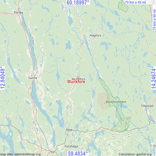
Munkfors GPS coordinates[2]
59° 50' 18.816" North, 13° 32' 36.996" East
| Map corner | latitude | longitude |
|---|---|---|
| Upper-left | 60.18997°, | 12.84049° |
| Center: | 59.83856°, | 13.54361° |
| Lower-right: | 59.4834°, | 14.24674° |
| Map W x H: | 78.6×78.6 km | = 48.8×48.8mi |
| max Lat: | 67.85572° ⇑28.5% North |
| Munkfors: | 59.83856° |
| min Lat: | ⇓71.5% South 55.34337° |
| min Long | Munkfors | max Long |
| 11.1712° | 13.54361° | 24.13676° |
| W 29.6%⇐ | ⇒70.4% E |
Elevation
Elevation of Munkfors is 97 m = 318 ft, and this is 14.4 m = 47 ft above average elevation for this country.
| Max E: |
663 m = 2175 ft | 30.7% |
| Munkfors | 97 m 318 ft | |
| Avg. | 82.6 m = 271 ft | |
Min E: |
-1 m = -3 ft | 69.3% |
See also: Sweden elevation on elevation.city.
Geographical zone
Munkfors is located in North temperate zone (between Tropic of Cancer and the Arctic Circle). Distance of this North polar circle is 747.7 km =464.6 mi to North.| Distance of | km | miles | from Munkfors |
|---|---|---|---|
| North Pole | 3353.6 | 2083.8 | to North |
| Arctic Circle | 747.7 | 464.6 | to North |
| Tropic Cancer | 4047.5 | 2515 | to South |
| Equator | 6653.4 | 4134.2 | to South |


Nearby cities:
15 places around Munkfors: (largest is in red/bold)
• Deje
26.5 km =16.5 mi,  188°
188°
• Edane
46.5 km =28.9 mi,  239°
239°
• Ekshärad
37.3 km =23.2 mi,  355°
355°
• Filipstad
37.7 km =23.4 mi,  111°
111°
• Forshaga
35 km =21.7 mi, 185°
• Hagfors
21.8 km =13.5 mi,  19°
19°
• Kil
39.6 km =24.6 mi,  199°
199°
• Lesjöfors
38.8 km =24.1 mi,  66°
66°
• Molkom
28.3 km =17.6 mi,  159°
159°
• Skattkärr
48 km =29.8 mi,  171°
171°
• Skåre
45.5 km =28.3 mi, 187°
• Sunne
22.4 km =13.9 mi,  269°
269°
• Torsby
44.4 km =27.6 mi,  317°
317°
• Uddeholm
20.2 km =12.6 mi,  11°
11°
• Vallargärdet
40.2 km =25 mi,  176°
176°
Sources, notices
• [Note1] Compared only with cities in Sweden existing in our database
• [Src1] Map data: © OpenStreetMap contributors (CC-BY-SA)
• [Src2] Other city data from geonames.org with taken over terms of usage.
• [Src3] Geographical zone / Annual Mean Temperature by Robert A. Rohde @ Wikipedia
