Lesjöfors geodata
Lesjöfors (Värmland) is a populated place; located in Sweden in Europe/Stockholm (GMT+2) time zone. With population of 948 people, there are 850 cities with bigger population in this country. Compared to other cities in Sweden, 73.4% of cities are located further ↓South; 61% of cities are located further →East and 94.4% of cities have lower elevation than Lesjöfors. Note1


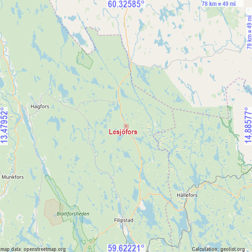
Lesjöfors GPS coordinates[2]
59° 58' 33.24" North, 14° 10' 57.504" East
| Map corner | latitude | longitude |
|---|---|---|
| Upper-left | 60.32585°, | 13.47952° |
| Center: | 59.9759°, | 14.18264° |
| Lower-right: | 59.62221°, | 14.88577° |
| Map W x H: | 78.2×78.2 km | = 48.6×48.6mi |
| max Lat: | 67.85572° ⇑26.6% North |
| Lesjöfors: | 59.9759° |
| min Lat: | ⇓73.4% South 55.34337° |
| min Long | Lesjöfors | max Long |
| 11.1712° | 14.18264° | 24.13676° |
| W 39%⇐ | ⇒61% E |
Elevation
Elevation of Lesjöfors is 251 m = 823 ft, and this is 168.4 m = 552 ft above average elevation for this country.
| Max E: |
663 m = 2175 ft | 5.6% |
| Lesjöfors | 251 m 823 ft | |
| Avg. | 82.6 m = 271 ft | |
Min E: |
-1 m = -3 ft | 94.4% |
See also: Sweden elevation on elevation.city.
Geographical zone
Lesjöfors is located in North temperate zone (between Tropic of Cancer and the Arctic Circle). Distance of this North polar circle is 732.5 km =455.2 mi to North.| Distance of | km | miles | from Lesjöfors |
|---|---|---|---|
| North Pole | 3338.4 | 2074.4 | to North |
| Arctic Circle | 732.5 | 455.2 | to North |
| Tropic Cancer | 4062.8 | 2524.5 | to South |
| Equator | 6668.7 | 4143.7 | to South |


Nearby cities:
15 places around Lesjöfors: (largest is in red/bold)
• Abborrberget
39.3 km =24.4 mi,  60°
60°
• Ekshärad
43.9 km =27.3 mi,  299°
299°
• Filipstad
29.3 km =18.2 mi,  181°
181°
• Fredriksberg
20.7 km =12.9 mi,  32°
32°
• Grythyttan
35.9 km =22.3 mi,  146°
146°
• Grängesberg
47.1 km =29.3 mi,  76°
76°
• Hagfors
28.9 km =18 mi,  280°
280°
• Hällefors
28.5 km =17.7 mi,  138°
138°
• Kopparberg
46.6 km =29 mi,  103°
103°
• Molkom
49.1 km =30.5 mi,  211°
211°
• Munkfors
38.8 km =24.1 mi,  246°
246°
• Nykroppa
39.8 km =24.7 mi,  170°
170°
• Saxdalen
48.4 km =30.1 mi,  66°
66°
• Storfors
49.6 km =30.8 mi, 174°
• Uddeholm
31.8 km =19.8 mi, 278°
Sources, notices
• [Note1] Compared only with cities in Sweden existing in our database
• [Src1] Map data: © OpenStreetMap contributors (CC-BY-SA)
• [Src2] Other city data from geonames.org with taken over terms of usage.
• [Src3] Geographical zone / Annual Mean Temperature by Robert A. Rohde @ Wikipedia
