Mörarp geodata
Mörarp (Skåne) is a populated place; located in Sweden in Europe/Stockholm (GMT+2) time zone. With population of 1,935 people, there are 539 cities with bigger population in this country. Compared to other cities in Sweden, 91.3% of cities are located further ↑North; 82.9% of cities are located further →East and 50.2% of cities have higher elevation than Mörarp. Note1
Administrative division(s):
- Level 1: Skåne
- Level 2: Helsingborg
- Level 3: Mörarp-Hässlunda
- Level 4: Mörarp socken


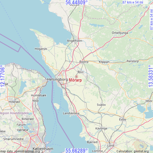
Mörarp GPS coordinates[2]
56° 3' 26.964" North, 12° 52' 48.648" East
| Map corner | latitude | longitude |
|---|---|---|
| Upper-left | 56.44809°, | 12.17706° |
| Center: | 56.05749°, | 12.88018° |
| Lower-right: | 55.66289°, | 13.58331° |
| Map W x H: | 87.3×87.3 km | = 54.2×54.2mi |
| max Lat: | 67.85572° ⇑91.3% North |
| Mörarp: | 56.05749° |
| min Lat: | ⇓8.7% South 55.34337° |
| min Long | Mörarp | max Long |
| 11.1712° | 12.88018° | 24.13676° |
| W 17.1%⇐ | ⇒82.9% E |
Elevation
Elevation of Mörarp is 50 m = 164 ft, and this is 32.6 m = 107 ft below average elevation for this country.
| Max E: |
663 m = 2175 ft | 50.2% |
| Avg. | 82.6 m = 271 ft | |
| Mörarp | 50 m = 164 ft | |
Min E: |
-1 m = -3 ft | 49.8% |
See also: Sweden elevation on elevation.city.
Geographical zone
Mörarp is located in North temperate zone (between Tropic of Cancer and the Arctic Circle). Distance of this North polar circle is 1168.2 km =725.9 mi to North.| Distance of | km | miles | from Mörarp |
|---|---|---|---|
| North Pole | 3774.1 | 2345.1 | to North |
| Arctic Circle | 1168.2 | 725.9 | to North |
| Tropic Cancer | 3627.1 | 2253.8 | to South |
| Equator | 6233 | 3873 | to South |


Nearby cities:
15 places around Mörarp: (largest is in red/bold)
• Billesholm
7.5 km =4.7 mi,  96°
96°
• Bjuv
3.8 km =2.4 mi,  39°
39°
• Björnås
9.2 km =5.7 mi, 35°
• Bårslöv
7.1 km =4.4 mi,  220°
220°
• Ekeby
8.4 km =5.2 mi,  139°
139°
• Gantofta
9.1 km =5.7 mi,  210°
210°
• Hasslarp
9.3 km =5.8 mi,  334°
334°
• Helsingborg
11.6 km =7.2 mi,  264°
264°
• Hyllinge
5.1 km =3.2 mi,  338°
338°
• Kattarp
11 km =6.8 mi, 326°
• Påarp
4.8 km =3 mi,  235°
235°
• Rydebäck
12.3 km =7.6 mi, 214°
• Vallåkra
10.8 km =6.7 mi,  187°
187°
• Åstorp
9.6 km =6 mi,  24°
24°
• Ödåkra
9.7 km =6 mi,  302°
302°
Sources, notices
• [Note1] Compared only with cities in Sweden existing in our database
• [Src1] Map data: © OpenStreetMap contributors (CC-BY-SA)
• [Src2] Other city data from geonames.org with taken over terms of usage.
• [Src3] Geographical zone / Annual Mean Temperature by Robert A. Rohde @ Wikipedia
