Bårslöv geodata
Bårslöv (Skåne) is a populated place; located in Sweden in Europe/Stockholm (GMT+2) time zone. With population of 2,753 people, there are 432 cities with bigger population in this country. Compared to other cities in Sweden, 92.5% of cities are located further ↑North; 84.6% of cities are located further →East and 50.7% of cities have higher elevation than Bårslöv. Note1


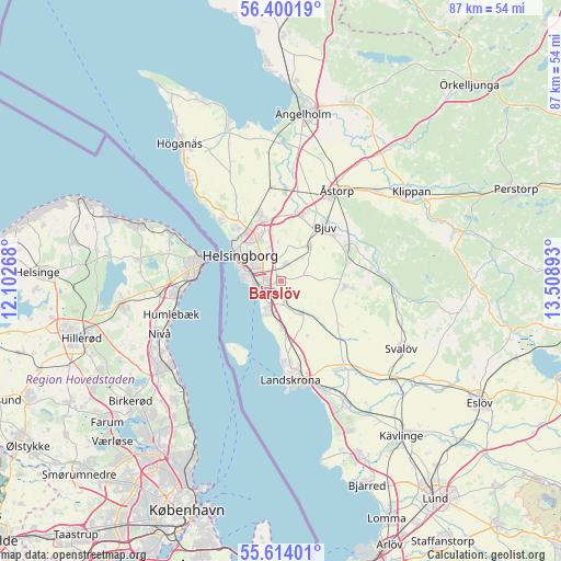
Bårslöv GPS coordinates[2]
56° 0' 32.76" North, 12° 48' 20.88" East
| Map corner | latitude | longitude |
|---|---|---|
| Upper-left | 56.40019°, | 12.10268° |
| Center: | 56.0091°, | 12.8058° |
| Lower-right: | 55.61401°, | 13.50893° |
| Map W x H: | 87.4×87.4 km | = 54.3×54.3mi |
| max Lat: | 67.85572° ⇑92.5% North |
| Bårslöv: | 56.0091° |
| min Lat: | ⇓7.5% South 55.34337° |
| min Long | Bårslöv | max Long |
| 11.1712° | 12.8058° | 24.13676° |
| W 15.4%⇐ | ⇒84.6% E |
Elevation
Elevation of Bårslöv is 49 m = 161 ft, and this is 33.6 m = 110 ft below average elevation for this country.
| Max E: |
663 m = 2175 ft | 50.7% |
| Avg. | 82.6 m = 271 ft | |
| Bårslöv | 49 m = 161 ft | |
Min E: |
-1 m = -3 ft | 49.3% |
See also: Sweden elevation on elevation.city.
Geographical zone
Bårslöv is located in North temperate zone (between Tropic of Cancer and the Arctic Circle). Distance of this North polar circle is 1173.5 km =729.2 mi to North.| Distance of | km | miles | from Bårslöv |
|---|---|---|---|
| North Pole | 3779.4 | 2348.4 | to North |
| Arctic Circle | 1173.5 | 729.2 | to North |
| Tropic Cancer | 3621.7 | 2250.4 | to South |
| Equator | 6227.6 | 3869.7 | to South |


Nearby cities:
15 places around Bårslöv: (largest is in red/bold)
• Allerum
14.2 km =8.8 mi,  330°
330°
• Billesholm
12.9 km =8 mi,  69°
69°
• Bjuv
10.9 km =6.8 mi,  40°
40°
• Ekeby
10.1 km =6.3 mi,  95°
95°
• Gantofta
2.4 km =1.5 mi,  181°
181°
• Glumslöv
7.6 km =4.7 mi, 178°
• Hasslarp
13.8 km =8.6 mi,  2°
2°
• Helsingborg
8.1 km =5 mi,  301°
301°
• Hittarp
14.7 km =9.1 mi,  313°
313°
• Hyllinge
10.5 km =6.5 mi,  15°
15°
• Mörarp
7.1 km =4.4 mi, 40°
• Påarp
2.8 km =1.7 mi,  14°
14°
• Rydebäck
5.3 km =3.3 mi,  207°
207°
• Vallåkra
6.2 km =3.9 mi,  149°
149°
• Ödåkra
11.2 km =7 mi,  341°
341°
Sources, notices
• [Note1] Compared only with cities in Sweden existing in our database
• [Src1] Map data: © OpenStreetMap contributors (CC-BY-SA)
• [Src2] Other city data from geonames.org with taken over terms of usage.
• [Src3] Geographical zone / Annual Mean Temperature by Robert A. Rohde @ Wikipedia
