Billingsfors geodata
Billingsfors (Västra Götaland) is a populated place; located in Sweden in Europe/Stockholm (GMT+2) time zone. With population of 1,108 people, there are 768 cities with bigger population in this country. Compared to other cities in Sweden, 53% of cities are located further ↓South; 91.3% of cities are located further →East and 67.2% of cities have lower elevation than Billingsfors. Note1


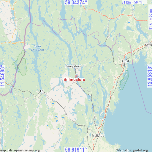
Billingsfors GPS coordinates[2]
58° 58' 59.988" North, 12° 15' 0" East
| Map corner | latitude | longitude |
|---|---|---|
| Upper-left | 59.34374°, | 11.54688° |
| Center: | 58.98333°, | 12.25° |
| Lower-right: | 58.61911°, | 12.95313° |
| Map W x H: | 80.6×80.6 km | = 50.1×50.1mi |
| max Lat: | 67.85572° ⇑47% North |
| Billingsfors: | 58.98333° |
| min Lat: | ⇓53% South 55.34337° |
| min Long | Billingsfors | max Long |
| 11.1712° | 12.25° | 24.13676° |
| W 8.7%⇐ | ⇒91.3% E |
Elevation
Elevation of Billingsfors is 90 m = 295 ft, and this is 7.4 m = 24 ft above average elevation for this country.
| Max E: |
663 m = 2175 ft | 32.8% |
| Billingsfors | 90 m 295 ft | |
| Avg. | 82.6 m = 271 ft | |
Min E: |
-1 m = -3 ft | 67.2% |
See also: Sweden elevation on elevation.city.
Geographical zone
Billingsfors is located in North temperate zone (between Tropic of Cancer and the Arctic Circle). Distance of this North polar circle is 842.8 km =523.7 mi to North.| Distance of | km | miles | from Billingsfors |
|---|---|---|---|
| North Pole | 3448.7 | 2142.9 | to North |
| Arctic Circle | 842.8 | 523.7 | to North |
| Tropic Cancer | 3952.4 | 2455.9 | to South |
| Equator | 6558.3 | 4075.1 | to South |


Nearby cities:
15 places around Billingsfors: (largest is in red/bold)
• Bengtsfors
5.2 km =3.2 mi,  348°
348°
• Brålanda
47 km =29.2 mi,  173°
173°
• Bäckefors
20.5 km =12.7 mi,  194°
194°
• Dals Långed
7.3 km =4.5 mi,  152°
152°
• Dals Rostock
30.2 km =18.8 mi, 169°
• Ed
19.8 km =12.3 mi,  246°
246°
• Fjällbacka
19.6 km =12.2 mi,  67°
67°
• Färgelanda
48.5 km =30.1 mi,  197°
197°
• Mellerud
33.6 km =20.9 mi,  159°
159°
• Säffle
42.2 km =26.2 mi, 66°
• Åmål
27.1 km =16.8 mi, 73°
• Årjäng
45.9 km =28.5 mi, 351°
• Åsensbruk
22.8 km =14.2 mi, 154°
• Ödeborg
51.3 km =31.9 mi, 198°
• Ödsmål
53.1 km =33 mi,  236°
236°
Sources, notices
• [Note1] Compared only with cities in Sweden existing in our database
• [Src1] Map data: © OpenStreetMap contributors (CC-BY-SA)
• [Src2] Other city data from geonames.org with taken over terms of usage.
• [Src3] Geographical zone / Annual Mean Temperature by Robert A. Rohde @ Wikipedia
