Bengtsfors geodata
Bengtsfors (Västra Götaland) is a seat of a second-order administrative division; located in Sweden in Europe/Stockholm (GMT+2) time zone. With population of 3,125 people, there are 394 cities with bigger population in this country. Compared to other cities in Sweden, 53.8% of cities are located further ↓South; 91.4% of cities are located further →East and 70.5% of cities have lower elevation than Bengtsfors. Note1


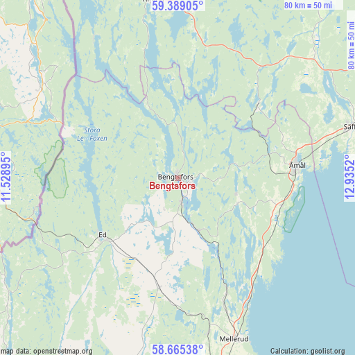
Bengtsfors GPS coordinates[2]
59° 1' 44.832" North, 12° 13' 55.452" East
| Map corner | latitude | longitude |
|---|---|---|
| Upper-left | 59.38905°, | 11.52895° |
| Center: | 59.02912°, | 12.23207° |
| Lower-right: | 58.66538°, | 12.9352° |
| Map W x H: | 80.5×80.5 km | = 50×50mi |
| max Lat: | 67.85572° ⇑46.2% North |
| Bengtsfors: | 59.02912° |
| min Lat: | ⇓53.8% South 55.34337° |
| min Long | Bengtsfors | max Long |
| 11.1712° | 12.23207° | 24.13676° |
| W 8.6%⇐ | ⇒91.4% E |
Elevation
Elevation of Bengtsfors is 100 m = 328 ft, and this is 17.4 m = 57 ft above average elevation for this country.
| Max E: |
663 m = 2175 ft | 29.5% |
| Bengtsfors | 100 m 328 ft | |
| Avg. | 82.6 m = 271 ft | |
Min E: |
-1 m = -3 ft | 70.5% |
See also: Sweden elevation on elevation.city.
Geographical zone
Bengtsfors is located in North temperate zone (between Tropic of Cancer and the Arctic Circle). Distance of this North polar circle is 837.8 km =520.6 mi to North.| Distance of | km | miles | from Bengtsfors |
|---|---|---|---|
| North Pole | 3443.6 | 2139.8 | to North |
| Arctic Circle | 837.8 | 520.6 | to North |
| Tropic Cancer | 3957.5 | 2459.1 | to South |
| Equator | 6563.4 | 4078.3 | to South |


Nearby cities:
15 places around Bengtsfors: (largest is in red/bold)
• Billingsfors
5.2 km =3.2 mi,  168°
168°
• Brålanda
52.2 km =32.4 mi, 172°
• Bäckefors
25.3 km =15.7 mi,  189°
189°
• Dals Långed
12.3 km =7.6 mi,  159°
159°
• Dals Rostock
35.4 km =22 mi, 168°
• Ed
21.5 km =13.4 mi,  232°
232°
• Fjällbacka
19.3 km =12 mi,  83°
83°
• Färgelanda
53.1 km =33 mi,  195°
195°
• Mellerud
38.8 km =24.1 mi, 160°
• Säffle
41.4 km =25.7 mi,  73°
73°
• Åmål
27.2 km =16.9 mi, 84°
• Årjäng
40.8 km =25.4 mi,  352°
352°
• Åsensbruk
27.8 km =17.3 mi, 156°
• Ödeborg
55.8 km =34.7 mi, 195°
• Ödsmål
55.3 km =34.4 mi, 231°
Sources, notices
• [Note1] Compared only with cities in Sweden existing in our database
• [Src1] Map data: © OpenStreetMap contributors (CC-BY-SA)
• [Src2] Other city data from geonames.org with taken over terms of usage.
• [Src3] Geographical zone / Annual Mean Temperature by Robert A. Rohde @ Wikipedia
