Brålanda geodata
Brålanda (Västra Götaland) is a populated place; located in Sweden in Europe/Stockholm (GMT+2) time zone. With population of 1,521 people, there are 651 cities with bigger population in this country. Compared to other cities in Sweden, 51.5% of cities are located further ↑North; 90% of cities are located further →East and 59.9% of cities have lower elevation than Brålanda. Note1


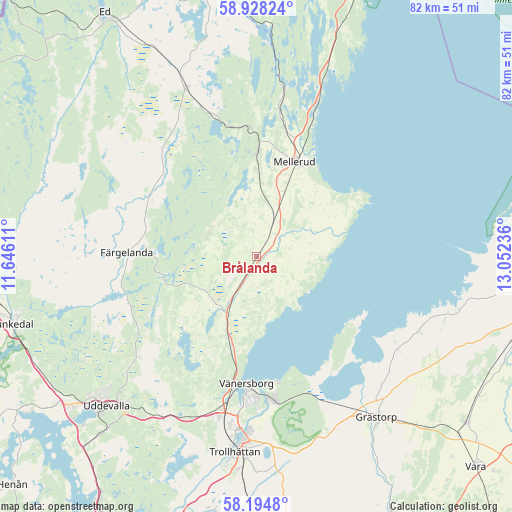
Brålanda GPS coordinates[2]
58° 33' 48.384" North, 12° 20' 57.228" East
| Map corner | latitude | longitude |
|---|---|---|
| Upper-left | 58.92824°, | 11.64611° |
| Center: | 58.56344°, | 12.34923° |
| Lower-right: | 58.1948°, | 13.05236° |
| Map W x H: | 81.6×81.5 km | = 50.7×50.6mi |
| max Lat: | 67.85572° ⇑51.5% North |
| Brålanda: | 58.56344° |
| min Lat: | ⇓48.5% South 55.34337° |
| min Long | Brålanda | max Long |
| 11.1712° | 12.34923° | 24.13676° |
| W 10%⇐ | ⇒90% E |
Elevation
Elevation of Brålanda is 71 m = 233 ft, and this is 11.6 m = 38 ft below average elevation for this country.
| Max E: |
663 m = 2175 ft | 40.1% |
| Avg. | 82.6 m = 271 ft | |
| Brålanda | 71 m = 233 ft | |
Min E: |
-1 m = -3 ft | 59.9% |
See also: Sweden elevation on elevation.city.
Geographical zone
Brålanda is located in North temperate zone (between Tropic of Cancer and the Arctic Circle). Distance of this North polar circle is 889.5 km =552.7 mi to North.| Distance of | km | miles | from Brålanda |
|---|---|---|---|
| North Pole | 3495.4 | 2171.9 | to North |
| Arctic Circle | 889.5 | 552.7 | to North |
| Tropic Cancer | 3905.7 | 2426.9 | to South |
| Equator | 6511.6 | 4046.1 | to South |


Nearby cities:
15 places around Brålanda: (largest is in red/bold)
• Bäckefors
28.9 km =18 mi,  338°
338°
• Dals Långed
40.3 km =25 mi,  356°
356°
• Dals Rostock
17 km =10.6 mi,  0°
0°
• Frändefors
8 km =5 mi,  208°
208°
• Färgelanda
20.7 km =12.9 mi,  271°
271°
• Grästorp
32.2 km =20 mi,  143°
143°
• Mellerud
16.3 km =10.1 mi,  21°
21°
• Sunningen
39.4 km =24.5 mi,  229°
229°
• Trollhättan
31.3 km =19.4 mi,  186°
186°
• Uddevalla
33.7 km =20.9 mi,  224°
224°
• Vargön
23.2 km =14.4 mi,  174°
174°
• Velanda
37.3 km =23.2 mi,  183°
183°
• Vänersborg
20.4 km =12.7 mi, 184°
• Åsensbruk
26.5 km =16.5 mi,  9°
9°
• Ödeborg
21.8 km =13.5 mi,  264°
264°
Sources, notices
• [Note1] Compared only with cities in Sweden existing in our database
• [Src1] Map data: © OpenStreetMap contributors (CC-BY-SA)
• [Src2] Other city data from geonames.org with taken over terms of usage.
• [Src3] Geographical zone / Annual Mean Temperature by Robert A. Rohde @ Wikipedia
