Filsbäck geodata
Filsbäck (Västra Götaland) is a populated place; located in Sweden in Europe/Stockholm (GMT+2) time zone. With population of 689 people, there are 1075 cities with bigger population in this country. Compared to other cities in Sweden, 52.9% of cities are located further ↑North; 74.9% of cities are located further →East and 50.2% of cities have higher elevation than Filsbäck. Note1
Administrative division(s):
- Level 1: Västra Götaland
- Level 2: Lidköpings Kommun
- Level 3: Sävare
- Level 4: Sävare socken


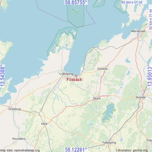
Filsbäck GPS coordinates[2]
58° 29' 31.2" North, 13° 14' 49.2" East
| Map corner | latitude | longitude |
|---|---|---|
| Upper-left | 58.85755°, | 12.54388° |
| Center: | 58.492°, | 13.247° |
| Lower-right: | 58.12261°, | 13.95013° |
| Map W x H: | 81.7×81.7 km | = 50.8×50.8mi |
| max Lat: | 67.85572° ⇑52.9% North |
| Filsbäck: | 58.492° |
| min Lat: | ⇓47.1% South 55.34337° |
| min Long | Filsbäck | max Long |
| 11.1712° | 13.247° | 24.13676° |
| W 25.1%⇐ | ⇒74.9% E |
Elevation
Elevation of Filsbäck is 50 m = 164 ft, and this is 32.6 m = 107 ft below average elevation for this country.
| Max E: |
663 m = 2175 ft | 50.2% |
| Avg. | 82.6 m = 271 ft | |
| Filsbäck | 50 m = 164 ft | |
Min E: |
-1 m = -3 ft | 49.8% |
See also: Sweden elevation on elevation.city.
Geographical zone
Filsbäck is located in North temperate zone (between Tropic of Cancer and the Arctic Circle). Distance of this North polar circle is 897.5 km =557.7 mi to North.| Distance of | km | miles | from Filsbäck |
|---|---|---|---|
| North Pole | 3503.4 | 2176.9 | to North |
| Arctic Circle | 897.5 | 557.7 | to North |
| Tropic Cancer | 3897.8 | 2422 | to South |
| Equator | 6503.7 | 4041.2 | to South |


Nearby cities:
15 places around Filsbäck: (largest is in red/bold)
• Ardala
15.4 km =9.6 mi,  160°
160°
• Axvall
22.2 km =13.8 mi,  123°
123°
• Götene
14.9 km =9.3 mi,  74°
74°
• Hällekis
18.9 km =11.7 mi,  35°
35°
• Järpås
20.3 km =12.6 mi,  233°
233°
• Kvänum
21.7 km =13.5 mi,  189°
189°
• Källby
4 km =2.5 mi,  59°
59°
• Lerdala
27.1 km =16.8 mi,  93°
93°
• Lidköping
5.4 km =3.4 mi,  285°
285°
• Lundsbrunn
11.9 km =7.4 mi,  100°
100°
• Skara
16.2 km =10.1 mi,  136°
136°
• Stora Levene
26.4 km =16.4 mi, 225°
• Timmersdala
29.6 km =18.4 mi,  81°
81°
• Varnhem
26.4 km =16.4 mi, 117°
• Vinninga
4.8 km =3 mi,  166°
166°
Sources, notices
• [Note1] Compared only with cities in Sweden existing in our database
• [Src1] Map data: © OpenStreetMap contributors (CC-BY-SA)
• [Src2] Other city data from geonames.org with taken over terms of usage.
• [Src3] Geographical zone / Annual Mean Temperature by Robert A. Rohde @ Wikipedia
